Hutang geodata
Hutang (Jiangsu) is a populated place; located in China in Asia/Shanghai (GMT+8) time zone. With population of 56,370 people, there are 778 cities with bigger population in this country. Compared to other cities in China, 58.6% of cities are located further ↓South; 78.7% of cities are located further ←West and 91.2% of cities have higher elevation than Hutang. Note1


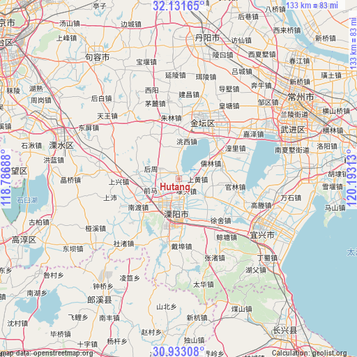
Hutang GPS coordinates[2]
31° 32' 3.444" North, 119° 29' 24" East
| Map corner | latitude | longitude |
|---|---|---|
| Upper-left | 32.13165°, | 118.78688° |
| Center: | 31.53429°, | 119.49° |
| Lower-right: | 30.93308°, | 120.19313° |
| Map W x H: | 133.3×133.3 km | = 82.8×82.8mi |
| max Lat: | 53.31946° ⇑41.4% North |
| Hutang: | 31.53429° |
| min Lat: | ⇓58.6% South 18.22056° |
| min Long | Hutang | max Long |
| 75.07348° | 119.49° | 134.28917° |
| W 78.7%⇐ | ⇒21.3% E |
Elevation
Elevation of Hutang is 9 m = 30 ft, and this is 475.8 m = 1561 ft below average elevation for this country.
| Max E: |
5622 m = 18445 ft | 91.2% |
| Avg. | 484.8 m = 1591 ft | |
| Hutang | 9 m = 30 ft | |
Min E: |
-3 m = -10 ft | 8.8% |
See also: Hutang elevation on elevation.city.
Geographical zone
Hutang is located in North temperate zone (between Tropic of Cancer and the Arctic Circle). Distance of this Northern Tropic circle is 900.4 km =559.5 mi to South.| Distance of | km | miles | from Hutang |
|---|---|---|---|
| North Pole | 6500.8 | 4039.4 | to North |
| Arctic Circle | 3894.9 | 2420.2 | to North |
| Tropic Cancer | 900.4 | 559.5 | to South |
| Equator | 3506.3 | 2178.7 | to South |


Nearby cities:
15 places around Hutang: (largest is in red/bold)
• Bieqiao
3.9 km =2.4 mi,  313°
313°
• Daitou
5 km =3.1 mi,  148°
148°
• Guanlin
21.3 km =13.2 mi,  99°
99°
• Licheng
11.8 km =7.3 mi,  182°
182°
• Nandu
16.2 km =10.1 mi,  223°
223°
• Nandu
18.4 km =11.4 mi,  235°
235°
• Rulin
13.5 km =8.4 mi,  63°
63°
• Shanghuang
7.2 km =4.5 mi,  80°
80°
• Shangxing
19.5 km =12.1 mi,  261°
261°
• Xinjian
16.1 km =10 mi, 79°
• Yangxiang
11.2 km =7 mi,  124°
124°
• Yong’an
17.8 km =11.1 mi,  49°
49°
• Zhiqian
9.4 km =5.8 mi,  359°
359°
• Zhuze
12.5 km =7.8 mi,  281°
281°
• Zhuze
15.9 km =9.9 mi, 280°
Sources, notices
• [Note1] Compared only with cities in China existing in our database
• [Src1] Map data: © OpenStreetMap contributors (CC-BY-SA)
• [Src2] Other city data from geonames.org with taken over terms of usage.
• [Src3] Geographical zone / Annual Mean Temperature by Robert A. Rohde @ Wikipedia
