Liujiading geodata
Liujiading (Tianjin) is a populated place; located in China in Asia/Shanghai (GMT+8) time zone. With population of 540 people, there are 1260 cities with bigger population in this country. Compared to other cities in China, 86.3% of cities are located further ↓South; 67.1% of cities are located further ←West and 83.4% of cities have higher elevation than Liujiading. Note1


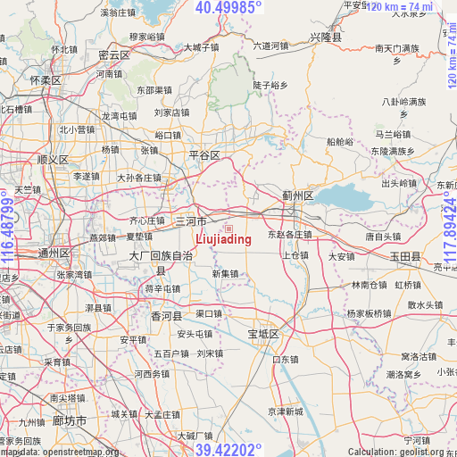
Liujiading GPS coordinates[2]
39° 57' 47.016" North, 117° 11' 27.996" East
| Map corner | latitude | longitude |
|---|---|---|
| Upper-left | 40.49985°, | 116.48799° |
| Center: | 39.96306°, | 117.19111° |
| Lower-right: | 39.42202°, | 117.89424° |
| Map W x H: | 119.8×119.8 km | = 74.4×74.4mi |
| max Lat: | 53.31946° ⇑13.7% North |
| Liujiading: | 39.96306° |
| min Lat: | ⇓86.3% South 18.22056° |
| min Long | Liujiading | max Long |
| 75.07348° | 117.19111° | 134.28917° |
| W 67.1%⇐ | ⇒32.9% E |
Elevation
Elevation of Liujiading is 19 m = 62 ft, and this is 465.8 m = 1528 ft below average elevation for this country.
| Max E: |
5622 m = 18445 ft | 83.4% |
| Avg. | 484.8 m = 1591 ft | |
| Liujiading | 19 m = 62 ft | |
Min E: |
-3 m = -10 ft | 16.6% |
See also: China elevation on elevation.city.
Geographical zone
Liujiading is located in North temperate zone (between Tropic of Cancer and the Arctic Circle). Distance of this Northern Tropic circle is 1837.6 km =1141.8 mi to South.| Distance of | km | miles | from Liujiading |
|---|---|---|---|
| North Pole | 5563.6 | 3457.1 | to North |
| Arctic Circle | 2957.7 | 1837.8 | to North |
| Tropic Cancer | 1837.6 | 1141.8 | to South |
| Equator | 4443.5 | 2761.1 | to South |


Nearby cities:
15 places around Liujiading: (largest is in red/bold)
• Baijian
3.8 km =2.4 mi,  23°
23°
• Bangjun
6.9 km =4.3 mi,  62°
62°
• Donggaocun
17.3 km =10.7 mi,  337°
337°
• Dongshigu
15.1 km =9.4 mi,  128°
128°
• Dongtazhuang
14.6 km =9.1 mi,  121°
121°
• Dongzhaogezhuang
15.3 km =9.5 mi,  95°
95°
• Dong’erying
7.5 km =4.7 mi,  94°
94°
• Goutou
17.6 km =10.9 mi,  177°
177°
• Liuzikou
16.8 km =10.4 mi, 127°
• Lizhuangzi
10.3 km =6.4 mi,  78°
78°
• Panggezhuang
17.7 km =11 mi,  186°
186°
• Sangzi
7 km =4.3 mi,  204°
204°
• Touying
2.3 km =1.4 mi, 87°
• Yinliu
17.6 km =10.9 mi, 82°
• Youguzhuang
7.9 km =4.9 mi,  143°
143°
Sources, notices
• [Note1] Compared only with cities in China existing in our database
• [Src1] Map data: © OpenStreetMap contributors (CC-BY-SA)
• [Src2] Other city data from geonames.org with taken over terms of usage.
• [Src3] Geographical zone / Annual Mean Temperature by Robert A. Rohde @ Wikipedia
