Sangzi geodata
Sangzi (Tianjin) is a populated place; located in China in Asia/Shanghai (GMT+8) time zone. With population of 4,315 people, there are 885 cities with bigger population in this country. Compared to other cities in China, 86.1% of cities are located further ↓South; 66.8% of cities are located further ←West and 82.9% of cities have higher elevation than Sangzi. Note1


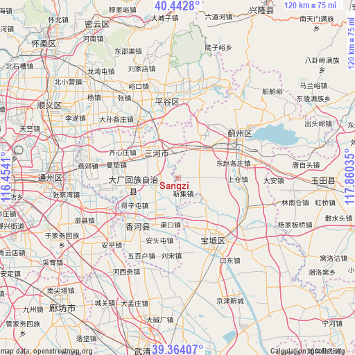
Sangzi GPS coordinates[2]
39° 54' 20.016" North, 117° 9' 25.992" East
| Map corner | latitude | longitude |
|---|---|---|
| Upper-left | 40.4428°, | 116.4541° |
| Center: | 39.90556°, | 117.15722° |
| Lower-right: | 39.36407°, | 117.86035° |
| Map W x H: | 119.9×119.9 km | = 74.5×74.5mi |
| max Lat: | 53.31946° ⇑13.9% North |
| Sangzi: | 39.90556° |
| min Lat: | ⇓86.1% South 18.22056° |
| min Long | Sangzi | max Long |
| 75.07348° | 117.15722° | 134.28917° |
| W 66.8%⇐ | ⇒33.2% E |
Elevation
Elevation of Sangzi is 20 m = 66 ft, and this is 464.8 m = 1525 ft below average elevation for this country.
| Max E: |
5622 m = 18445 ft | 82.9% |
| Avg. | 484.8 m = 1591 ft | |
| Sangzi | 20 m = 66 ft | |
Min E: |
-3 m = -10 ft | 17.1% |
See also: China elevation on elevation.city.
Geographical zone
Sangzi is located in North temperate zone (between Tropic of Cancer and the Arctic Circle). Distance of this Northern Tropic circle is 1831.2 km =1137.9 mi to South.| Distance of | km | miles | from Sangzi |
|---|---|---|---|
| North Pole | 5570 | 3461 | to North |
| Arctic Circle | 2964.1 | 1841.8 | to North |
| Tropic Cancer | 1831.2 | 1137.9 | to South |
| Equator | 4437.1 | 2757.1 | to South |


Nearby cities:
15 places around Sangzi: (largest is in red/bold)
• Baijian
10.8 km =6.7 mi,  23°
23°
• Bangjun
13.1 km =8.1 mi,  43°
43°
• Dongshigu
15.1 km =9.4 mi,  101°
101°
• Dongtazhuang
15.4 km =9.6 mi,  94°
94°
• Dongzhaogezhuang
18.8 km =11.7 mi,  75°
75°
• Dong’erying
11.9 km =7.4 mi,  60°
60°
• Goutou
11.7 km =7.3 mi,  162°
162°
• Liujiading
7 km =4.3 mi, 24°
• Liuzikou
16.6 km =10.3 mi, 103°
• Lizhuangzi
15.5 km =9.6 mi, 56°
• Niudaokou
15.6 km =9.7 mi,  148°
148°
• Panggezhuang
11.2 km =7 mi,  176°
176°
• Touying
8.3 km =5.2 mi, 38°
• Youguzhuang
7.6 km =4.7 mi, 89°
• Zhaogezhuang
13.9 km =8.6 mi,  166°
166°
Sources, notices
• [Note1] Compared only with cities in China existing in our database
• [Src1] Map data: © OpenStreetMap contributors (CC-BY-SA)
• [Src2] Other city data from geonames.org with taken over terms of usage.
• [Src3] Geographical zone / Annual Mean Temperature by Robert A. Rohde @ Wikipedia
