Liufu geodata
Liufu (Anhui) is a seat of a fourth-order administrative division; located in China in Asia/Shanghai (GMT+8) time zone. In our database, there are 1268 cities with bigger population. Compared to other cities in China, 65.1% of cities are located further ↓South; 68% of cities are located further ←West and 74.8% of cities have higher elevation than Liufu. Note1


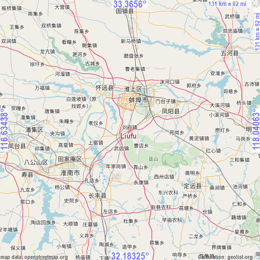
Liufu GPS coordinates[2]
32° 46' 35.004" North, 117° 20' 15" East
| Map corner | latitude | longitude |
|---|---|---|
| Upper-left | 33.3656°, | 116.63438° |
| Center: | 32.77639°, | 117.3375° |
| Lower-right: | 32.18325°, | 118.04063° |
| Map W x H: | 131.5×131.5 km | = 81.7×81.7mi |
| max Lat: | 53.31946° ⇑34.9% North |
| Liufu: | 32.77639° |
| min Lat: | ⇓65.1% South 18.22056° |
| min Long | Liufu | max Long |
| 75.07348° | 117.3375° | 134.28917° |
| W 68%⇐ | ⇒32% E |
Elevation
Elevation of Liufu is 37 m = 121 ft, and this is 447.8 m = 1469 ft below average elevation for this country.
| Max E: |
5622 m = 18445 ft | 74.8% |
| Avg. | 484.8 m = 1591 ft | |
| Liufu | 37 m = 121 ft | |
Min E: |
-3 m = -10 ft | 25.2% |
See also: China elevation on elevation.city.
Geographical zone
Liufu is located in North temperate zone (between Tropic of Cancer and the Arctic Circle). Distance of this Northern Tropic circle is 1038.5 km =645.3 mi to South.| Distance of | km | miles | from Liufu |
|---|---|---|---|
| North Pole | 6362.7 | 3953.6 | to North |
| Arctic Circle | 3756.8 | 2334.4 | to North |
| Tropic Cancer | 1038.5 | 645.3 | to South |
| Equator | 3644.4 | 2264.5 | to South |


Nearby cities:
15 places around Liufu: (largest is in red/bold)
• Bengbu
18.4 km =11.4 mi,  6°
6°
• Datong
31 km =19.3 mi,  236°
236°
• Dingcheng
41.8 km =26 mi,  133°
133°
• Fengtai Chengguanzhen
57.4 km =35.7 mi,  262°
262°
• Fengyang Fuchengzhen
22.5 km =14 mi,  59°
59°
• Gudian
76.1 km =47.3 mi,  278°
278°
• Guzhen Chengguanzhen
59.4 km =36.9 mi,  357°
357°
• Huainan
36 km =22.4 mi, 242°
• Huaiyuan Chengguanzhen
25.9 km =16.1 mi,  321°
321°
• Jiulonggang
29.7 km =18.5 mi,  234°
234°
• Lingcheng
86.6 km =53.8 mi, 12°
• Mingguang
58.5 km =36.4 mi,  89°
89°
• Shouchun
55.4 km =34.4 mi,  246°
246°
• Wuhe Chengguanzhen
63.7 km =39.6 mi,  50°
50°
• Yaokou
63.6 km =39.5 mi, 235°
Sources, notices
• [Note1] Compared only with cities in China existing in our database
• [Src1] Map data: © OpenStreetMap contributors (CC-BY-SA)
• [Src2] Other city data from geonames.org with taken over terms of usage.
• [Src3] Geographical zone / Annual Mean Temperature by Robert A. Rohde @ Wikipedia
