Chang’an geodata
Chang’an (Hunan) is a seat of a third-order administrative division; located in China in Asia/Shanghai (GMT+8) time zone. In our database, there are 1268 cities with bigger population. Compared to other cities in China, 60% of cities are located further ↑North; 54.7% of cities are located further →East and 70% of cities have higher elevation than Chang’an. Note1


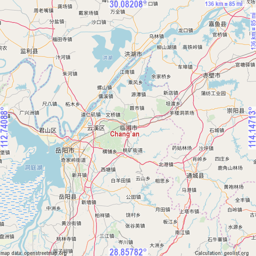
Chang’an GPS coordinates[2]
29° 28' 18.48" North, 113° 26' 38.4" East
| Map corner | latitude | longitude |
|---|---|---|
| Upper-left | 30.08208°, | 112.74088° |
| Center: | 29.4718°, | 113.444° |
| Lower-right: | 28.85782°, | 114.14713° |
| Map W x H: | 136.1×136.1 km | = 84.6×84.6mi |
| max Lat: | 53.31946° ⇑60% North |
| Chang’an: | 29.4718° |
| min Lat: | ⇓40% South 18.22056° |
| min Long | Chang’an | max Long |
| 75.07348° | 113.444° | 134.28917° |
| W 45.3%⇐ | ⇒54.7% E |
Elevation
Elevation of Chang’an is 52 m = 171 ft, and this is 432.8 m = 1420 ft below average elevation for this country.
| Max E: |
5622 m = 18445 ft | 70% |
| Avg. | 484.8 m = 1591 ft | |
| Chang’an | 52 m = 171 ft | |
Min E: |
-3 m = -10 ft | 30% |
See also: China elevation on elevation.city.
Geographical zone
Chang’an is located in North temperate zone (between Tropic of Cancer and the Arctic Circle). Distance of this Northern Tropic circle is 671 km =416.9 mi to South.| Distance of | km | miles | from Chang’an |
|---|---|---|---|
| North Pole | 6730.1 | 4181.9 | to North |
| Arctic Circle | 4124.2 | 2562.7 | to North |
| Tropic Cancer | 671 | 416.9 | to South |
| Equator | 3277 | 2036.2 | to South |


Nearby cities:
15 places around Chang’an: (largest is in red/bold)
• Bailuo
24.9 km =15.5 mi,  290°
290°
• Beigang
27.7 km =17.2 mi,  133°
133°
• Cha’anling
37.6 km =23.4 mi,  62°
62°
• Daping
28.6 km =17.8 mi,  123°
123°
• Luoshan
25.3 km =15.7 mi,  329°
329°
• Qiaoshi
36.8 km =22.9 mi,  315°
315°
• Shinan
33.7 km =20.9 mi, 129°
• Xiaoling
37.5 km =23.3 mi,  111°
111°
• Xindi
38.4 km =23.9 mi,  3°
3°
• Xindian
29.7 km =18.5 mi,  49°
49°
• Yangloudong
30 km =18.6 mi,  75°
75°
• Yueyang
35.5 km =22.1 mi,  252°
252°
• Yunxi
19.2 km =11.9 mi,  270°
270°
• Zhaoliqiao
28 km =17.4 mi,  67°
67°
• Zhemu
32.3 km =20.1 mi, 293°
Sources, notices
• [Note1] Compared only with cities in China existing in our database
• [Src1] Map data: © OpenStreetMap contributors (CC-BY-SA)
• [Src2] Other city data from geonames.org with taken over terms of usage.
• [Src3] Geographical zone / Annual Mean Temperature by Robert A. Rohde @ Wikipedia
