Shinan geodata
Shinan (Hubei) is a seat of a fourth-order administrative division; located in China in Asia/Shanghai (GMT+8) time zone. In our database, there are 1268 cities with bigger population. Compared to other cities in China, 62.3% of cities are located further ↑North; 53% of cities are located further →East and 58.5% of cities have higher elevation than Shinan. Note1


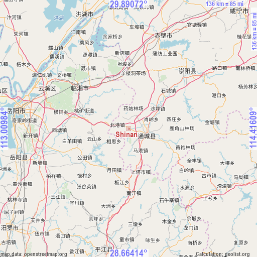
Shinan GPS coordinates[2]
29° 16' 45.372" North, 113° 42' 46.656" East
| Map corner | latitude | longitude |
|---|---|---|
| Upper-left | 29.89072°, | 113.00984° |
| Center: | 29.27927°, | 113.71296° |
| Lower-right: | 28.66414°, | 114.41609° |
| Map W x H: | 136.4×136.4 km | = 84.8×84.8mi |
| max Lat: | 53.31946° ⇑62.3% North |
| Shinan: | 29.27927° |
| min Lat: | ⇓37.7% South 18.22056° |
| min Long | Shinan | max Long |
| 75.07348° | 113.71296° | 134.28917° |
| W 47%⇐ | ⇒53% E |
Elevation
Elevation of Shinan is 108 m = 354 ft, and this is 376.8 m = 1236 ft below average elevation for this country.
| Max E: |
5622 m = 18445 ft | 58.5% |
| Avg. | 484.8 m = 1591 ft | |
| Shinan | 108 m = 354 ft | |
Min E: |
-3 m = -10 ft | 41.5% |
See also: China elevation on elevation.city.
Geographical zone
Shinan is located in North temperate zone (between Tropic of Cancer and the Arctic Circle). Distance of this Northern Tropic circle is 649.6 km =403.6 mi to South.| Distance of | km | miles | from Shinan |
|---|---|---|---|
| North Pole | 6751.5 | 4195.2 | to North |
| Arctic Circle | 4145.6 | 2576 | to North |
| Tropic Cancer | 649.6 | 403.6 | to South |
| Equator | 3255.5 | 2022.9 | to South |


Nearby cities:
15 places around Shinan: (largest is in red/bold)
• Beigang
6.5 km =4 mi,  289°
289°
• Daping
6 km =3.7 mi,  338°
338°
• Guandao
19.4 km =12.1 mi,  110°
110°
• Juanshui
17.1 km =10.6 mi,  81°
81°
• Magang
12.1 km =7.5 mi,  151°
151°
• Maishi
26.6 km =16.5 mi,  116°
116°
• Shadui
18.2 km =11.3 mi, 80°
• Shaping
18.7 km =11.6 mi,  54°
54°
• Shicheng
29.3 km =18.2 mi, 45°
• Sizhuang
23.4 km =14.5 mi, 77°
• Tanghu
27.2 km =16.9 mi, 105°
• Wuli
9.4 km =5.8 mi,  134°
134°
• Xiaoling
11.9 km =7.4 mi, 48°
• Yangloudong
29.3 km =18.2 mi,  5°
5°
• Zhaoliqiao
32.1 km =19.9 mi,  359°
359°
Sources, notices
• [Note1] Compared only with cities in China existing in our database
• [Src1] Map data: © OpenStreetMap contributors (CC-BY-SA)
• [Src2] Other city data from geonames.org with taken over terms of usage.
• [Src3] Geographical zone / Annual Mean Temperature by Robert A. Rohde @ Wikipedia
