Xindian geodata
Xindian (Hubei) is a seat of a fourth-order administrative division; located in China in Asia/Shanghai (GMT+8) time zone. In our database, there are 1268 cities with bigger population. Compared to other cities in China, 58% of cities are located further ↑North; 53.2% of cities are located further →East and 76.7% of cities have higher elevation than Xindian. Note1


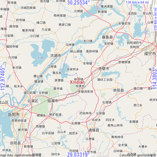
Xindian GPS coordinates[2]
29° 38' 46.032" North, 113° 40' 37.812" East
| Map corner | latitude | longitude |
|---|---|---|
| Upper-left | 30.25534°, | 112.97405° |
| Center: | 29.64612°, | 113.67717° |
| Lower-right: | 29.03319°, | 114.3803° |
| Map W x H: | 135.9×135.9 km | = 84.4×84.4mi |
| max Lat: | 53.31946° ⇑58% North |
| Xindian: | 29.64612° |
| min Lat: | ⇓42% South 18.22056° |
| min Long | Xindian | max Long |
| 75.07348° | 113.67717° | 134.28917° |
| W 46.8%⇐ | ⇒53.2% E |
Elevation
Elevation of Xindian is 33 m = 108 ft, and this is 451.8 m = 1482 ft below average elevation for this country.
| Max E: |
5622 m = 18445 ft | 76.7% |
| Avg. | 484.8 m = 1591 ft | |
| Xindian | 33 m = 108 ft | |
Min E: |
-3 m = -10 ft | 23.3% |
See also: China elevation on elevation.city.
Geographical zone
Xindian is located in North temperate zone (between Tropic of Cancer and the Arctic Circle). Distance of this Northern Tropic circle is 690.4 km =429 mi to South.| Distance of | km | miles | from Xindian |
|---|---|---|---|
| North Pole | 6710.7 | 4169.8 | to North |
| Arctic Circle | 4104.8 | 2550.6 | to North |
| Tropic Cancer | 690.4 | 429 | to South |
| Equator | 3296.3 | 2048.2 | to South |


Nearby cities:
15 places around Xindian: (largest is in red/bold)
• Chang’an
29.7 km =18.5 mi,  229°
229°
• Cha’anling
10.8 km =6.7 mi,  99°
99°
• Chebu
15.8 km =9.8 mi,  30°
30°
• Chibi
26.3 km =16.3 mi,  348°
348°
• Gaotieling
26.4 km =16.4 mi,  24°
24°
• Guihuaquan
21.3 km =13.2 mi,  117°
117°
• Liushanhu
24.2 km =15 mi, 353°
• Longkou
33.7 km =20.9 mi,  13°
13°
• Luxi
30.1 km =18.7 mi,  0°
0°
• Puqi
21.4 km =13.3 mi,  68°
68°
• Shicheng
31.4 km =19.5 mi,  129°
129°
• Wulin
30.7 km =19.1 mi, 345°
• Xindi
27.8 km =17.3 mi,  313°
313°
• Yangloudong
13.3 km =8.3 mi,  151°
151°
• Zhaoliqiao
9.3 km =5.8 mi,  158°
158°
Sources, notices
• [Note1] Compared only with cities in China existing in our database
• [Src1] Map data: © OpenStreetMap contributors (CC-BY-SA)
• [Src2] Other city data from geonames.org with taken over terms of usage.
• [Src3] Geographical zone / Annual Mean Temperature by Robert A. Rohde @ Wikipedia
