Xiaoling geodata
Xiaoling (Hubei) is a seat of a fourth-order administrative division; located in China in Asia/Shanghai (GMT+8) time zone. In our database, there are 1268 cities with bigger population. Compared to other cities in China, 61.3% of cities are located further ↑North; 52.5% of cities are located further →East and 59% of cities have higher elevation than Xiaoling. Note1


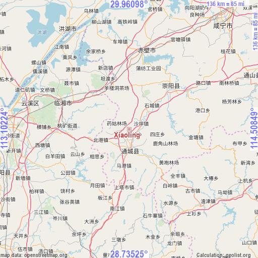
Xiaoling GPS coordinates[2]
29° 20' 59.856" North, 113° 48' 19.296" East
| Map corner | latitude | longitude |
|---|---|---|
| Upper-left | 29.96098°, | 113.10224° |
| Center: | 29.34996°, | 113.80536° |
| Lower-right: | 28.73525°, | 114.50849° |
| Map W x H: | 136.3×136.3 km | = 84.7×84.7mi |
| max Lat: | 53.31946° ⇑61.3% North |
| Xiaoling: | 29.34996° |
| min Lat: | ⇓38.7% South 18.22056° |
| min Long | Xiaoling | max Long |
| 75.07348° | 113.80536° | 134.28917° |
| W 47.5%⇐ | ⇒52.5% E |
Elevation
Elevation of Xiaoling is 104 m = 341 ft, and this is 380.8 m = 1249 ft below average elevation for this country.
| Max E: |
5622 m = 18445 ft | 59% |
| Avg. | 484.8 m = 1591 ft | |
| Xiaoling | 104 m = 341 ft | |
Min E: |
-3 m = -10 ft | 41% |
See also: China elevation on elevation.city.
Geographical zone
Xiaoling is located in North temperate zone (between Tropic of Cancer and the Arctic Circle). Distance of this Northern Tropic circle is 657.5 km =408.6 mi to South.| Distance of | km | miles | from Xiaoling |
|---|---|---|---|
| North Pole | 6743.7 | 4190.3 | to North |
| Arctic Circle | 4137.8 | 2571.1 | to North |
| Tropic Cancer | 657.5 | 408.6 | to South |
| Equator | 3263.4 | 2027.8 | to South |


Nearby cities:
15 places around Xiaoling: (largest is in red/bold)
• Beigang
16.1 km =10 mi,  249°
249°
• Daping
11.4 km =7.1 mi,  258°
258°
• Guandao
17.4 km =10.8 mi,  148°
148°
• Guihuaquan
24.2 km =15 mi,  15°
15°
• Juanshui
9.5 km =5.9 mi,  123°
123°
• Magang
18.7 km =11.6 mi,  189°
189°
• Qingshan
23 km =14.3 mi,  64°
64°
• Shadui
10.2 km =6.3 mi, 118°
• Shaping
7 km =4.3 mi,  65°
65°
• Shicheng
17.4 km =10.8 mi,  42°
42°
• Shinan
11.9 km =7.4 mi,  228°
228°
• Sizhuang
14.2 km =8.8 mi,  101°
101°
• Tanghu
22.9 km =14.2 mi,  131°
131°
• Wuli
14.6 km =9.1 mi, 189°
• Yangloudong
22.1 km =13.7 mi,  344°
344°
Sources, notices
• [Note1] Compared only with cities in China existing in our database
• [Src1] Map data: © OpenStreetMap contributors (CC-BY-SA)
• [Src2] Other city data from geonames.org with taken over terms of usage.
• [Src3] Geographical zone / Annual Mean Temperature by Robert A. Rohde @ Wikipedia
