Hetou geodata
Hetou (Zhejiang) is a seat of a fourth-order administrative division; located in China in Asia/Shanghai (GMT+8) time zone. In our database, there are 1268 cities with bigger population. Compared to other cities in China, 65.5% of cities are located further ↑North; 88.2% of cities are located further ←West and 75.3% of cities have higher elevation than Hetou. Note1


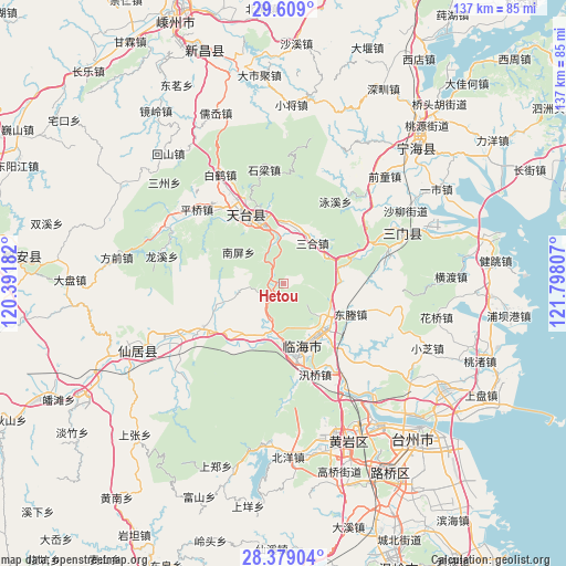
Hetou GPS coordinates[2]
28° 59' 45.06" North, 121° 5' 41.784" East
| Map corner | latitude | longitude |
|---|---|---|
| Upper-left | 29.609°, | 120.39182° |
| Center: | 28.99585°, | 121.09494° |
| Lower-right: | 28.37904°, | 121.79807° |
| Map W x H: | 136.8×136.8 km | = 85×85mi |
| max Lat: | 53.31946° ⇑65.5% North |
| Hetou: | 28.99585° |
| min Lat: | ⇓34.5% South 18.22056° |
| min Long | Hetou | max Long |
| 75.07348° | 121.09494° | 134.28917° |
| W 88.2%⇐ | ⇒11.8% E |
Elevation
Elevation of Hetou is 36 m = 118 ft, and this is 448.8 m = 1472 ft below average elevation for this country.
| Max E: |
5622 m = 18445 ft | 75.3% |
| Avg. | 484.8 m = 1591 ft | |
| Hetou | 36 m = 118 ft | |
Min E: |
-3 m = -10 ft | 24.7% |
See also: China elevation on elevation.city.
Geographical zone
Hetou is located in North temperate zone (between Tropic of Cancer and the Arctic Circle). Distance of this Northern Tropic circle is 618.1 km =384.1 mi to South.| Distance of | km | miles | from Hetou |
|---|---|---|---|
| North Pole | 6783 | 4214.8 | to North |
| Arctic Circle | 4177.1 | 2595.5 | to North |
| Tropic Cancer | 618.1 | 384.1 | to South |
| Equator | 3224 | 2003.3 | to South |


Nearby cities:
15 places around Hetou: (largest is in red/bold)
• Baishuiyang
22.4 km =13.9 mi,  240°
240°
• Dacun
12 km =7.5 mi,  56°
56°
• Datian
14 km =8.7 mi,  134°
134°
• Dayang
15.3 km =9.5 mi,  158°
158°
• Dongcheng
18.6 km =11.6 mi,  113°
113°
• Gucheng
16.5 km =10.3 mi,  172°
172°
• Huangwu
12 km =7.5 mi,  35°
35°
• Huixi
12 km =7.5 mi, 109°
• Jiangnan
18.5 km =11.5 mi, 171°
• Kuocang
18.8 km =11.7 mi,  215°
215°
• Linhai
16.4 km =10.2 mi, 162°
• Tantou
13.1 km =8.1 mi,  10°
10°
• Tiantai Chengguanzhen
16.9 km =10.5 mi,  337°
337°
• Yongfeng
11.4 km =7.1 mi,  193°
193°
• Zhu’ao
20.3 km =12.6 mi,  66°
66°
Sources, notices
• [Note1] Compared only with cities in China existing in our database
• [Src1] Map data: © OpenStreetMap contributors (CC-BY-SA)
• [Src2] Other city data from geonames.org with taken over terms of usage.
• [Src3] Geographical zone / Annual Mean Temperature by Robert A. Rohde @ Wikipedia
