Lingyao geodata
Lingyao (Fujian) is a seat of a fourth-order administrative division; located in China in Asia/Shanghai (GMT+8) time zone. In our database, there are 1268 cities with bigger population. Compared to other cities in China, 76.7% of cities are located further ↑North; 75.9% of cities are located further ←West and 76.4% of cities have lower elevation than Lingyao. Note1


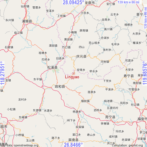
Lingyao GPS coordinates[2]
27° 28' 19.884" North, 118° 58' 57.468" East
| Map corner | latitude | longitude |
|---|---|---|
| Upper-left | 28.09425°, | 118.27951° |
| Center: | 27.47219°, | 118.98263° |
| Lower-right: | 26.8466°, | 119.68576° |
| Map W x H: | 138.7×138.7 km | = 86.2×86.2mi |
| max Lat: | 53.31946° ⇑76.7% North |
| Lingyao: | 27.47219° |
| min Lat: | ⇓23.3% South 18.22056° |
| min Long | Lingyao | max Long |
| 75.07348° | 118.98263° | 134.28917° |
| W 75.9%⇐ | ⇒24.1% E |
Elevation
Elevation of Lingyao is 556 m = 1824 ft, and this is 71.2 m = 234 ft above average elevation for this country.
| Max E: |
5622 m = 18445 ft | 23.6% |
| Lingyao | 556 m 1824 ft | |
| Avg. | 484.8 m = 1591 ft | |
Min E: |
-3 m = -10 ft | 76.4% |
See also: China elevation on elevation.city.
Geographical zone
Lingyao is located in North temperate zone (between Tropic of Cancer and the Arctic Circle). Distance of this Northern Tropic circle is 448.7 km =278.8 mi to South.| Distance of | km | miles | from Lingyao |
|---|---|---|---|
| North Pole | 6952.4 | 4320 | to North |
| Arctic Circle | 4346.6 | 2700.9 | to North |
| Tropic Cancer | 448.7 | 278.8 | to South |
| Equator | 3054.6 | 1898 | to South |


Nearby cities:
15 places around Lingyao: (largest is in red/bold)
• Annan
8.1 km =5 mi,  60°
60°
• Chaping
16.5 km =10.3 mi,  272°
272°
• Hedong
19.8 km =12.3 mi,  287°
287°
• Jiuxian
19.4 km =12.1 mi,  319°
319°
• Jushui
19 km =11.8 mi,  82°
82°
• Longgong
4.3 km =2.7 mi,  297°
297°
• Pingdu
15.7 km =9.8 mi,  354°
354°
• Songyuan
18.3 km =11.4 mi,  24°
24°
• Songyuan
21.2 km =13.2 mi, 286°
• Tieshan
9.9 km =6.2 mi,  214°
214°
• Waitun
15.3 km =9.5 mi,  177°
177°
• Wudabao
23.8 km =14.8 mi,  50°
50°
• Xingxi
16.9 km =10.5 mi,  226°
226°
• Xiongshan
17.2 km =10.7 mi, 225°
• Yushang
11.2 km =7 mi,  2°
2°
Sources, notices
• [Note1] Compared only with cities in China existing in our database
• [Src1] Map data: © OpenStreetMap contributors (CC-BY-SA)
• [Src2] Other city data from geonames.org with taken over terms of usage.
• [Src3] Geographical zone / Annual Mean Temperature by Robert A. Rohde @ Wikipedia
