Lincheng geodata
Lincheng (Hainan) is a seat of a third-order administrative division; located in China in Asia/Shanghai (GMT+8) time zone. With population of 64,874 people, there are 671 cities with bigger population in this country. Compared to other cities in China, 98.8% of cities are located further ↑North; 72.9% of cities are located further →East and 78.8% of cities have higher elevation than Lincheng. Note1


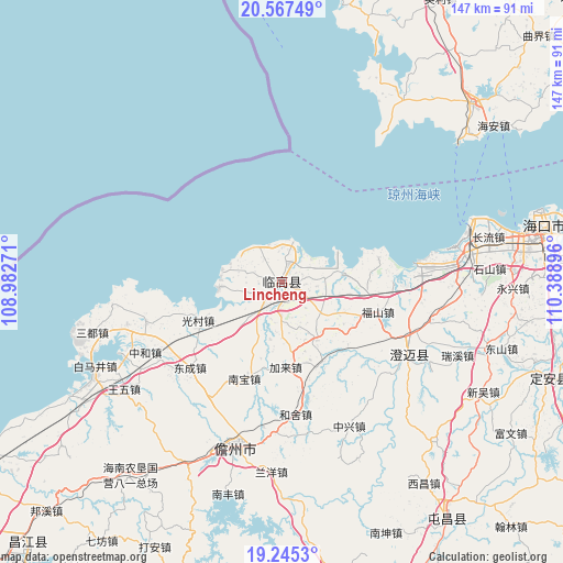
Lincheng GPS coordinates[2]
19° 54' 28.008" North, 109° 41' 8.988" East
| Map corner | latitude | longitude |
|---|---|---|
| Upper-left | 20.56749°, | 108.98271° |
| Center: | 19.90778°, | 109.68583° |
| Lower-right: | 19.2453°, | 110.38896° |
| Map W x H: | 147×147 km | = 91.3×91.3mi |
| max Lat: | 53.31946° ⇑98.8% North |
| Lincheng: | 19.90778° |
| min Lat: | ⇓1.2% South 18.22056° |
| min Long | Lincheng | max Long |
| 75.07348° | 109.68583° | 134.28917° |
| W 27.1%⇐ | ⇒72.9% E |
Elevation
Elevation of Lincheng is 29 m = 95 ft, and this is 455.8 m = 1495 ft below average elevation for this country.
| Max E: |
5622 m = 18445 ft | 78.8% |
| Avg. | 484.8 m = 1591 ft | |
| Lincheng | 29 m = 95 ft | |
Min E: |
-3 m = -10 ft | 21.2% |
See also: Lincheng elevation on elevation.city.
Geographical zone
Lincheng is located in North Torrid zone (between Equator and Tropic of Cancer). Distance of this Northern Tropic circle is 392.4 km =243.8 mi to North.| Distance of | km | miles | from Lincheng |
|---|---|---|---|
| North Pole | 7793.5 | 4842.7 | to North |
| Arctic Circle | 5187.6 | 3223.4 | to North |
| Tropic Cancer | 392.4 | 243.8 | to North |
| Equator | 2213.5 | 1375.4 | to South |


Nearby cities:
15 places around Lincheng: (largest is in red/bold)
• Bohou
6.4 km =4 mi,  117°
117°
• Bolian
6.3 km =3.9 mi,  226°
226°
• Dongcheng
32.7 km =20.3 mi, 227°
• Dongyin
7.4 km =4.6 mi,  322°
322°
• Duowen
16.9 km =10.5 mi,  150°
150°
• Fushan
26.4 km =16.4 mi,  107°
107°
• Guangcun
24 km =14.9 mi,  245°
245°
• Heshe
34.7 km =21.6 mi,  173°
173°
• Huangtong
18.4 km =11.4 mi, 116°
• Jialai
22.2 km =13.8 mi,  177°
177°
• Longbo
23.8 km =14.8 mi,  133°
133°
• Nanbao
26.8 km =16.7 mi,  200°
200°
• Qiaotou
25.9 km =16.1 mi,  75°
75°
• Tiaolou
16.1 km =10 mi,  282°
282°
• Xinying
16.9 km =10.5 mi,  264°
264°
Sources, notices
• [Note1] Compared only with cities in China existing in our database
• [Src1] Map data: © OpenStreetMap contributors (CC-BY-SA)
• [Src2] Other city data from geonames.org with taken over terms of usage.
• [Src3] Geographical zone / Annual Mean Temperature by Robert A. Rohde @ Wikipedia
