Lianjiangkou geodata
Lianjiangkou (Guangdong) is a seat of a fourth-order administrative division; located in China in Asia/Shanghai (GMT+8) time zone. In our database, there are 1268 cities with bigger population. Compared to other cities in China, 90.3% of cities are located further ↑North; 55.6% of cities are located further →East and 55.1% of cities have higher elevation than Lianjiangkou. Note1


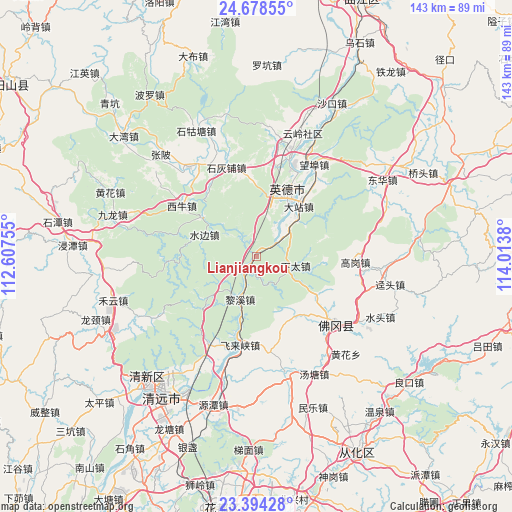
Lianjiangkou GPS coordinates[2]
24° 2' 16.872" North, 113° 18' 38.412" East
| Map corner | latitude | longitude |
|---|---|---|
| Upper-left | 24.67855°, | 112.60755° |
| Center: | 24.03802°, | 113.31067° |
| Lower-right: | 23.39428°, | 114.0138° |
| Map W x H: | 142.8×142.8 km | = 88.7×88.7mi |
| max Lat: | 53.31946° ⇑90.3% North |
| Lianjiangkou: | 24.03802° |
| min Lat: | ⇓9.7% South 18.22056° |
| min Long | Lianjiangkou | max Long |
| 75.07348° | 113.31067° | 134.28917° |
| W 44.4%⇐ | ⇒55.6% E |
Elevation
Elevation of Lianjiangkou is 131 m = 430 ft, and this is 353.8 m = 1161 ft below average elevation for this country.
| Max E: |
5622 m = 18445 ft | 55.1% |
| Avg. | 484.8 m = 1591 ft | |
| Lianjiangkou | 131 m = 430 ft | |
Min E: |
-3 m = -10 ft | 44.9% |
See also: China elevation on elevation.city.
Geographical zone
Lianjiangkou is located in North temperate zone (between Tropic of Cancer and the Arctic Circle). Distance of this Northern Tropic circle is 66.9 km =41.6 mi to South.| Distance of | km | miles | from Lianjiangkou |
|---|---|---|---|
| North Pole | 7334.3 | 4557.3 | to North |
| Arctic Circle | 4728.4 | 2938.1 | to North |
| Tropic Cancer | 66.9 | 41.6 | to South |
| Equator | 2672.8 | 1660.8 | to South |


Nearby cities:
15 places around Lianjiangkou: (largest is in red/bold)
• Dadong
24.5 km =15.2 mi,  267°
267°
• Dazhan
15.5 km =9.6 mi,  34°
34°
• Gaogang
27.4 km =17 mi,  93°
93°
• Gaotian
27.9 km =17.3 mi,  208°
208°
• Huanggang
21.8 km =13.5 mi,  60°
60°
• Lixi
11.7 km =7.3 mi, 209°
• Shaba
24 km =14.9 mi,  284°
284°
• Shihuipu
26.7 km =16.6 mi,  342°
342°
• Shijiao
29 km =18 mi,  130°
130°
• Shuibian
15.8 km =9.8 mi,  295°
295°
• Xiashitai
11.5 km =7.1 mi,  99°
99°
• Xiniu
24.5 km =15.2 mi, 304°
• Yingcheng
17.6 km =10.9 mi,  36°
36°
• Yingcheng
20.4 km =12.7 mi,  11°
11°
• Yinghong
30.6 km =19 mi,  18°
18°
Sources, notices
• [Note1] Compared only with cities in China existing in our database
• [Src1] Map data: © OpenStreetMap contributors (CC-BY-SA)
• [Src2] Other city data from geonames.org with taken over terms of usage.
• [Src3] Geographical zone / Annual Mean Temperature by Robert A. Rohde @ Wikipedia
