Xiashitai geodata
Xiashitai (Guangdong) is a seat of a fourth-order administrative division; located in China in Asia/Shanghai (GMT+8) time zone. In our database, there are 1268 cities with bigger population. Compared to other cities in China, 90.4% of cities are located further ↑North; 54.9% of cities are located further →East and 57.5% of cities have higher elevation than Xiashitai. Note1


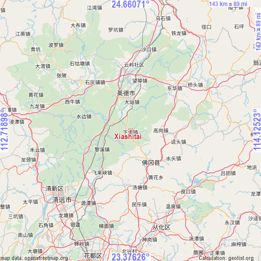
Xiashitai GPS coordinates[2]
24° 1' 12.324" North, 113° 25' 19.56" East
| Map corner | latitude | longitude |
|---|---|---|
| Upper-left | 24.66071°, | 112.71898° |
| Center: | 24.02009°, | 113.4221° |
| Lower-right: | 23.37626°, | 114.12523° |
| Map W x H: | 142.8×142.8 km | = 88.7×88.7mi |
| max Lat: | 53.31946° ⇑90.4% North |
| Xiashitai: | 24.02009° |
| min Lat: | ⇓9.6% South 18.22056° |
| min Long | Xiashitai | max Long |
| 75.07348° | 113.4221° | 134.28917° |
| W 45.1%⇐ | ⇒54.9% E |
Elevation
Elevation of Xiashitai is 114 m = 374 ft, and this is 370.8 m = 1217 ft below average elevation for this country.
| Max E: |
5622 m = 18445 ft | 57.5% |
| Avg. | 484.8 m = 1591 ft | |
| Xiashitai | 114 m = 374 ft | |
Min E: |
-3 m = -10 ft | 42.5% |
See also: China elevation on elevation.city.
Geographical zone
Xiashitai is located in North temperate zone (between Tropic of Cancer and the Arctic Circle). Distance of this Northern Tropic circle is 64.9 km =40.3 mi to South.| Distance of | km | miles | from Xiashitai |
|---|---|---|---|
| North Pole | 7336.3 | 4558.6 | to North |
| Arctic Circle | 4730.4 | 2939.3 | to North |
| Tropic Cancer | 64.9 | 40.3 | to South |
| Equator | 2670.8 | 1659.6 | to South |


Nearby cities:
15 places around Xiashitai: (largest is in red/bold)
• Dazhan
14.9 km =9.3 mi,  350°
350°
• Gaogang
16.1 km =10 mi,  89°
89°
• Huanggang
14.8 km =9.2 mi,  31°
31°
• Jingtou
26.5 km =16.5 mi,  102°
102°
• Lianjiangkou
11.5 km =7.1 mi,  279°
279°
• Lixi
18.9 km =11.7 mi,  244°
244°
• Longshan
30.2 km =18.8 mi,  186°
186°
• Shijiao
19.9 km =12.4 mi,  147°
147°
• Shuibian
27.1 km =16.8 mi,  288°
288°
• Shuitou
27.7 km =17.2 mi,  122°
122°
• Tangtang
31.1 km =19.3 mi,  171°
171°
• Wangbu
28.2 km =17.5 mi,  13°
13°
• Yingcheng
16.2 km =10.1 mi,  356°
356°
• Yingcheng
23.2 km =14.4 mi,  341°
341°
• Yuwan
29.4 km =18.3 mi,  57°
57°
Sources, notices
• [Note1] Compared only with cities in China existing in our database
• [Src1] Map data: © OpenStreetMap contributors (CC-BY-SA)
• [Src2] Other city data from geonames.org with taken over terms of usage.
• [Src3] Geographical zone / Annual Mean Temperature by Robert A. Rohde @ Wikipedia
