Gaotian geodata
Gaotian (Guangdong) is a seat of a fourth-order administrative division; located in China in Asia/Shanghai (GMT+8) time zone. In our database, there are 1268 cities with bigger population. Compared to other cities in China, 90.9% of cities are located further ↑North; 56.5% of cities are located further →East and 78.3% of cities have higher elevation than Gaotian. Note1


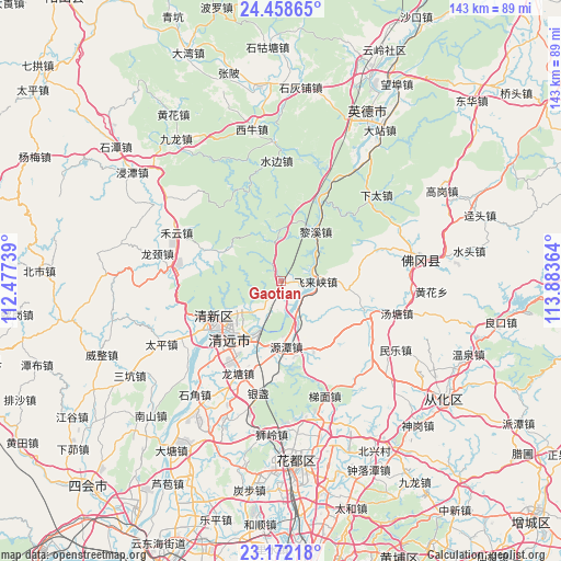
Gaotian GPS coordinates[2]
23° 49' 1.236" North, 113° 10' 49.836" East
| Map corner | latitude | longitude |
|---|---|---|
| Upper-left | 24.45865°, | 112.47739° |
| Center: | 23.81701°, | 113.18051° |
| Lower-right: | 23.17218°, | 113.88364° |
| Map W x H: | 143×143 km | = 88.9×88.9mi |
| max Lat: | 53.31946° ⇑90.9% North |
| Gaotian: | 23.81701° |
| min Lat: | ⇓9.1% South 18.22056° |
| min Long | Gaotian | max Long |
| 75.07348° | 113.18051° | 134.28917° |
| W 43.5%⇐ | ⇒56.5% E |
Elevation
Elevation of Gaotian is 30 m = 98 ft, and this is 454.8 m = 1492 ft below average elevation for this country.
| Max E: |
5622 m = 18445 ft | 78.3% |
| Avg. | 484.8 m = 1591 ft | |
| Gaotian | 30 m = 98 ft | |
Min E: |
-3 m = -10 ft | 21.7% |
See also: China elevation on elevation.city.
Geographical zone
Gaotian is located in North temperate zone (between Tropic of Cancer and the Arctic Circle). Distance of this Northern Tropic circle is 42.3 km =26.3 mi to South.| Distance of | km | miles | from Gaotian |
|---|---|---|---|
| North Pole | 7358.9 | 4572.6 | to North |
| Arctic Circle | 4753 | 2953.4 | to North |
| Tropic Cancer | 42.3 | 26.3 | to South |
| Equator | 2648.2 | 1645.5 | to South |


Nearby cities:
15 places around Gaotian: (largest is in red/bold)
• Dadong
26.2 km =16.3 mi,  334°
334°
• Dongcheng
15.6 km =9.7 mi,  232°
232°
• Feilaixia
8.5 km =5.3 mi,  139°
139°
• Fengcheng
17.8 km =11.1 mi,  239°
239°
• Henghe
23.9 km =14.9 mi,  211°
211°
• Heyun
29.4 km =18.3 mi,  295°
295°
• Jiangkou
9.8 km =6.1 mi,  155°
155°
• Lianjiangkou
27.9 km =17.3 mi,  28°
28°
• Lixi
16.2 km =10.1 mi, 27°
• Longshan
22.4 km =13.9 mi,  109°
109°
• Longtang
26.7 km =16.6 mi,  204°
204°
• Qingyuan
19.8 km =12.3 mi, 229°
• Taihe
22.5 km =14 mi,  246°
246°
• Yuantan
16.7 km =10.4 mi,  173°
173°
• Zhouxin
17.7 km =11 mi, 213°
Sources, notices
• [Note1] Compared only with cities in China existing in our database
• [Src1] Map data: © OpenStreetMap contributors (CC-BY-SA)
• [Src2] Other city data from geonames.org with taken over terms of usage.
• [Src3] Geographical zone / Annual Mean Temperature by Robert A. Rohde @ Wikipedia
