Kongwan geodata
Kongwan (Hubei) is a seat of a fourth-order administrative division; located in China in Asia/Shanghai (GMT+8) time zone. In our database, there are 1268 cities with bigger population. Compared to other cities in China, 58.9% of cities are located further ↓South; 61.4% of cities are located further →East and 69.2% of cities have higher elevation than Kongwan. Note1


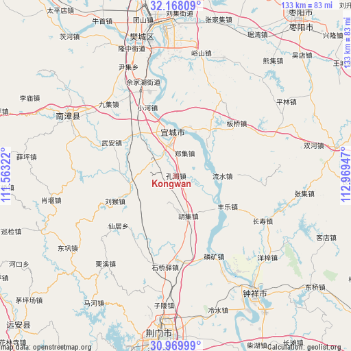
Kongwan GPS coordinates[2]
31° 34' 15.456" North, 112° 15' 58.824" East
| Map corner | latitude | longitude |
|---|---|---|
| Upper-left | 32.16809°, | 111.56322° |
| Center: | 31.57096°, | 112.26634° |
| Lower-right: | 30.96999°, | 112.96947° |
| Map W x H: | 133.2×133.2 km | = 82.8×82.8mi |
| max Lat: | 53.31946° ⇑41.1% North |
| Kongwan: | 31.57096° |
| min Lat: | ⇓58.9% South 18.22056° |
| min Long | Kongwan | max Long |
| 75.07348° | 112.26634° | 134.28917° |
| W 38.6%⇐ | ⇒61.4% E |
Elevation
Elevation of Kongwan is 55 m = 180 ft, and this is 429.8 m = 1410 ft below average elevation for this country.
| Max E: |
5622 m = 18445 ft | 69.2% |
| Avg. | 484.8 m = 1591 ft | |
| Kongwan | 55 m = 180 ft | |
Min E: |
-3 m = -10 ft | 30.8% |
See also: China elevation on elevation.city.
Geographical zone
Kongwan is located in North temperate zone (between Tropic of Cancer and the Arctic Circle). Distance of this Northern Tropic circle is 904.4 km =562 mi to South.| Distance of | km | miles | from Kongwan |
|---|---|---|---|
| North Pole | 6496.7 | 4036.9 | to North |
| Arctic Circle | 3890.8 | 2417.6 | to North |
| Tropic Cancer | 904.4 | 562 | to South |
| Equator | 3510.4 | 2181.3 | to South |


Nearby cities:
15 places around Kongwan: (largest is in red/bold)
• Banqiaodian
30.6 km =19 mi,  49°
49°
• Changshou
37.1 km =23.1 mi,  117°
117°
• Fengle
22.8 km =14.2 mi, 120°
• Huji
16 km =9.9 mi,  163°
163°
• Linkuang
33.9 km =21.1 mi,  154°
154°
• Liuhou
25.1 km =15.6 mi,  247°
247°
• Liushui
17.2 km =10.7 mi,  91°
91°
• Nanying
18.3 km =11.4 mi,  7°
7°
• Oumiao
33.6 km =20.9 mi,  343°
343°
• Shiqiaoyi
35.1 km =21.8 mi,  187°
187°
• Shuanghe
32.3 km =20.1 mi,  179°
179°
• Xianju
29.1 km =18.1 mi,  229°
229°
• Xiaohe
28.1 km =17.5 mi, 337°
• Yicheng
14.9 km =9.3 mi,  356°
356°
• Zhengji
9.2 km =5.7 mi,  20°
20°
Sources, notices
• [Note1] Compared only with cities in China existing in our database
• [Src1] Map data: © OpenStreetMap contributors (CC-BY-SA)
• [Src2] Other city data from geonames.org with taken over terms of usage.
• [Src3] Geographical zone / Annual Mean Temperature by Robert A. Rohde @ Wikipedia
