Shuanghe geodata
Shuanghe (Hubei) is a seat of a fourth-order administrative division; located in China in Asia/Shanghai (GMT+8) time zone. In our database, there are 1268 cities with bigger population. Compared to other cities in China, 56.8% of cities are located further ↓South; 61.3% of cities are located further →East and 68.4% of cities have higher elevation than Shuanghe. Note1


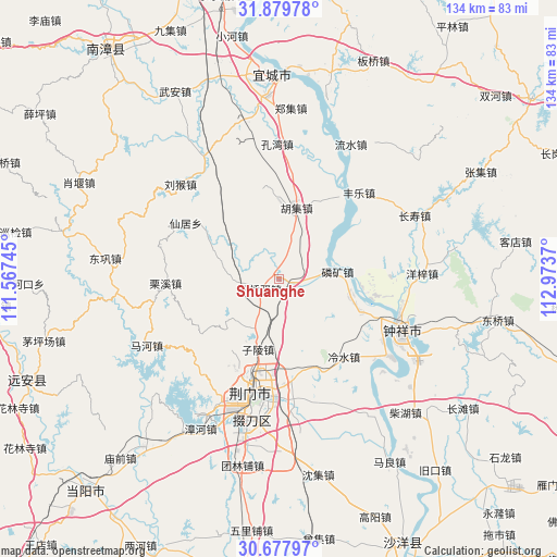
Shuanghe GPS coordinates[2]
31° 16' 50.844" North, 112° 16' 14.052" East
| Map corner | latitude | longitude |
|---|---|---|
| Upper-left | 31.87978°, | 111.56745° |
| Center: | 31.28079°, | 112.27057° |
| Lower-right: | 30.67797°, | 112.9737° |
| Map W x H: | 133.6×133.6 km | = 83×83mi |
| max Lat: | 53.31946° ⇑43.2% North |
| Shuanghe: | 31.28079° |
| min Lat: | ⇓56.8% South 18.22056° |
| min Long | Shuanghe | max Long |
| 75.07348° | 112.27057° | 134.28917° |
| W 38.7%⇐ | ⇒61.3% E |
Elevation
Elevation of Shuanghe is 58 m = 190 ft, and this is 426.8 m = 1400 ft below average elevation for this country.
| Max E: |
5622 m = 18445 ft | 68.4% |
| Avg. | 484.8 m = 1591 ft | |
| Shuanghe | 58 m = 190 ft | |
Min E: |
-3 m = -10 ft | 31.6% |
See also: China elevation on elevation.city.
Geographical zone
Shuanghe is located in North temperate zone (between Tropic of Cancer and the Arctic Circle). Distance of this Northern Tropic circle is 872.2 km =542 mi to South.| Distance of | km | miles | from Shuanghe |
|---|---|---|---|
| North Pole | 6529 | 4056.9 | to North |
| Arctic Circle | 3923.1 | 2437.7 | to North |
| Tropic Cancer | 872.2 | 542 | to South |
| Equator | 3478.1 | 2161.2 | to South |


Nearby cities:
15 places around Shuanghe: (largest is in red/bold)
• Baimiao
27.7 km =17.2 mi,  189°
189°
• Fengle
28.2 km =17.5 mi,  42°
42°
• Huji
17.5 km =10.9 mi,  14°
14°
• Jingmen
28.2 km =17.5 mi, 192°
• Kongwan
32.3 km =20.1 mi,  359°
359°
• Lengshui
24.4 km =15.2 mi,  140°
140°
• Linkuang
14.2 km =8.8 mi,  83°
83°
• Liuhou
32.7 km =20.3 mi,  313°
313°
• Lixi
27.3 km =17 mi,  267°
267°
• Pailou
25.2 km =15.7 mi,  177°
177°
• Shiqiaoyi
5.6 km =3.5 mi,  243°
243°
• Wenji
28 km =17.4 mi,  118°
118°
• Xianju
26.1 km =16.2 mi,  300°
300°
• Zhongxiang
32.3 km =20.1 mi,  113°
113°
• Zilingpu
17.3 km =10.7 mi,  196°
196°
Sources, notices
• [Note1] Compared only with cities in China existing in our database
• [Src1] Map data: © OpenStreetMap contributors (CC-BY-SA)
• [Src2] Other city data from geonames.org with taken over terms of usage.
• [Src3] Geographical zone / Annual Mean Temperature by Robert A. Rohde @ Wikipedia
