Liuhou geodata
Liuhou (Hubei) is a seat of a fourth-order administrative division; located in China in Asia/Shanghai (GMT+8) time zone. In our database, there are 1268 cities with bigger population. Compared to other cities in China, 58.3% of cities are located further ↓South; 62.6% of cities are located further →East and 58.2% of cities have higher elevation than Liuhou. Note1


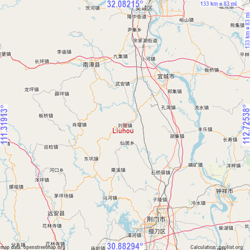
Liuhou GPS coordinates[2]
31° 29' 4.092" North, 112° 1' 20.1" East
| Map corner | latitude | longitude |
|---|---|---|
| Upper-left | 32.08215°, | 111.31913° |
| Center: | 31.48447°, | 112.02225° |
| Lower-right: | 30.88294°, | 112.72538° |
| Map W x H: | 133.3×133.3 km | = 82.8×82.8mi |
| max Lat: | 53.31946° ⇑41.7% North |
| Liuhou: | 31.48447° |
| min Lat: | ⇓58.3% South 18.22056° |
| min Long | Liuhou | max Long |
| 75.07348° | 112.02225° | 134.28917° |
| W 37.4%⇐ | ⇒62.6% E |
Elevation
Elevation of Liuhou is 110 m = 361 ft, and this is 374.8 m = 1230 ft below average elevation for this country.
| Max E: |
5622 m = 18445 ft | 58.2% |
| Avg. | 484.8 m = 1591 ft | |
| Liuhou | 110 m = 361 ft | |
Min E: |
-3 m = -10 ft | 41.8% |
See also: China elevation on elevation.city.
Geographical zone
Liuhou is located in North temperate zone (between Tropic of Cancer and the Arctic Circle). Distance of this Northern Tropic circle is 894.8 km =556 mi to South.| Distance of | km | miles | from Liuhou |
|---|---|---|---|
| North Pole | 6506.3 | 4042.8 | to North |
| Arctic Circle | 3900.4 | 2423.6 | to North |
| Tropic Cancer | 894.8 | 556 | to South |
| Equator | 3500.7 | 2175.2 | to South |


Nearby cities:
15 places around Liuhou: (largest is in red/bold)
• Chengguan
37.2 km =23.1 mi,  332°
332°
• Donggong
25.3 km =15.7 mi,  225°
225°
• Huji
28.4 km =17.6 mi,  101°
101°
• Kongwan
25.1 km =15.6 mi,  67°
67°
• Lixi
24 km =14.9 mi,  188°
188°
• Nanying
37.7 km =23.4 mi,  42°
42°
• Nanzhang Chengguanzhen
38.1 km =23.7 mi, 331°
• Shiqiaoyi
31.3 km =19.4 mi,  143°
143°
• Shuanghe
32.7 km =20.3 mi,  133°
133°
• Xianju
9.4 km =5.8 mi,  173°
173°
• Xiaohe
37.6 km =23.4 mi,  19°
19°
• Xiaoyan
24.3 km =15.1 mi,  271°
271°
• Xueping
37.6 km =23.4 mi,  296°
296°
• Yicheng
33 km =20.5 mi, 42°
• Zhengji
32.1 km =19.9 mi,  55°
55°
Sources, notices
• [Note1] Compared only with cities in China existing in our database
• [Src1] Map data: © OpenStreetMap contributors (CC-BY-SA)
• [Src2] Other city data from geonames.org with taken over terms of usage.
• [Src3] Geographical zone / Annual Mean Temperature by Robert A. Rohde @ Wikipedia
