Kanshi geodata
Kanshi (Fujian) is a seat of a fourth-order administrative division; located in China in Asia/Shanghai (GMT+8) time zone. In our database, there are 1268 cities with bigger population. Compared to other cities in China, 86.7% of cities are located further ↑North; 65.4% of cities are located further ←West and 61.1% of cities have lower elevation than Kanshi. Note1


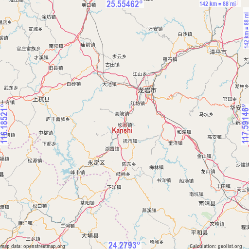
Kanshi GPS coordinates[2]
24° 55' 6.996" North, 116° 53' 17.988" East
| Map corner | latitude | longitude |
|---|---|---|
| Upper-left | 25.55462°, | 116.18521° |
| Center: | 24.91861°, | 116.88833° |
| Lower-right: | 24.2793°, | 117.59146° |
| Map W x H: | 141.8×141.8 km | = 88.1×88.1mi |
| max Lat: | 53.31946° ⇑86.7% North |
| Kanshi: | 24.91861° |
| min Lat: | ⇓13.3% South 18.22056° |
| min Long | Kanshi | max Long |
| 75.07348° | 116.88833° | 134.28917° |
| W 65.4%⇐ | ⇒34.6% E |
Elevation
Elevation of Kanshi is 272 m = 892 ft, and this is 212.8 m = 698 ft below average elevation for this country.
| Max E: |
5622 m = 18445 ft | 38.9% |
| Avg. | 484.8 m = 1591 ft | |
| Kanshi | 272 m = 892 ft | |
Min E: |
-3 m = -10 ft | 61.1% |
See also: China elevation on elevation.city.
Geographical zone
Kanshi is located in North temperate zone (between Tropic of Cancer and the Arctic Circle). Distance of this Northern Tropic circle is 164.8 km =102.4 mi to South.| Distance of | km | miles | from Kanshi |
|---|---|---|---|
| North Pole | 7236.4 | 4496.5 | to North |
| Arctic Circle | 4630.5 | 2877.3 | to North |
| Tropic Cancer | 164.8 | 102.4 | to South |
| Equator | 2770.7 | 1721.6 | to South |


Nearby cities:
15 places around Kanshi: (largest is in red/bold)
• Caoxi
22.2 km =13.8 mi,  40°
40°
• Chendong
22.2 km =13.8 mi,  174°
174°
• Dongxiao
17.2 km =10.7 mi, 44°
• Fushi
9.6 km =6 mi,  161°
161°
• Gaobei
6.9 km =4.3 mi,  345°
345°
• Hexi
17.1 km =10.6 mi,  255°
255°
• Hugang
12.9 km =8 mi,  312°
312°
• Hulei
15.6 km =9.7 mi,  208°
208°
• Longmen
21.4 km =13.3 mi,  21°
21°
• Nanyang
13.6 km =8.5 mi,  28°
28°
• Peifeng
5.3 km =3.3 mi,  104°
104°
• Tangbao
9.2 km =5.7 mi,  237°
237°
• Xipi
22.8 km =14.2 mi, 32°
• Xixi
21.9 km =13.6 mi,  225°
225°
• Yajin
24.9 km =15.5 mi,  337°
337°
Sources, notices
• [Note1] Compared only with cities in China existing in our database
• [Src1] Map data: © OpenStreetMap contributors (CC-BY-SA)
• [Src2] Other city data from geonames.org with taken over terms of usage.
• [Src3] Geographical zone / Annual Mean Temperature by Robert A. Rohde @ Wikipedia
