Jiuxian geodata
Jiuxian (Fujian) is a seat of a fourth-order administrative division; located in China in Asia/Shanghai (GMT+8) time zone. In our database, there are 1268 cities with bigger population. Compared to other cities in China, 85.5% of cities are located further ↑North; 63.1% of cities are located further ←West and 65.6% of cities have lower elevation than Jiuxian. Note1


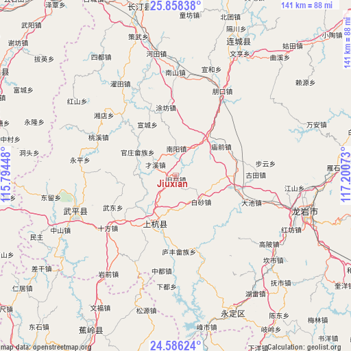
Jiuxian GPS coordinates[2]
25° 13' 26.292" North, 116° 29' 51.36" East
| Map corner | latitude | longitude |
|---|---|---|
| Upper-left | 25.85838°, | 115.79448° |
| Center: | 25.22397°, | 116.4976° |
| Lower-right: | 24.58624°, | 117.20073° |
| Map W x H: | 141.4×141.5 km | = 87.9×87.9mi |
| max Lat: | 53.31946° ⇑85.5% North |
| Jiuxian: | 25.22397° |
| min Lat: | ⇓14.5% South 18.22056° |
| min Long | Jiuxian | max Long |
| 75.07348° | 116.4976° | 134.28917° |
| W 63.1%⇐ | ⇒36.9% E |
Elevation
Elevation of Jiuxian is 337 m = 1106 ft, and this is 147.8 m = 485 ft below average elevation for this country.
| Max E: |
5622 m = 18445 ft | 34.4% |
| Avg. | 484.8 m = 1591 ft | |
| Jiuxian | 337 m = 1106 ft | |
Min E: |
-3 m = -10 ft | 65.6% |
See also: China elevation on elevation.city.
Geographical zone
Jiuxian is located in North temperate zone (between Tropic of Cancer and the Arctic Circle). Distance of this Northern Tropic circle is 198.7 km =123.5 mi to South.| Distance of | km | miles | from Jiuxian |
|---|---|---|---|
| North Pole | 7202.4 | 4475.4 | to North |
| Arctic Circle | 4596.5 | 2856.1 | to North |
| Tropic Cancer | 198.7 | 123.5 | to South |
| Equator | 2804.6 | 1742.7 | to South |


Nearby cities:
15 places around Jiuxian: (largest is in red/bold)
• Baisha
14.7 km =9.1 mi,  135°
135°
• Chadi
23.7 km =14.7 mi,  159°
159°
• Guanzhuang
18.1 km =11.2 mi,  301°
301°
• Jiaoyang
24 km =14.9 mi,  88°
88°
• Lincheng
20.4 km =12.7 mi,  206°
206°
• Linjiang
20.7 km =12.9 mi,  202°
202°
• Miaoqian
21.8 km =13.5 mi,  57°
57°
• Panjing
19.3 km =12 mi,  170°
170°
• Shangcai Zhongxing
9.3 km =5.8 mi, 298°
• Shanhu
17.2 km =10.7 mi,  272°
272°
• Shaxiaba
10.9 km =6.8 mi,  1°
1°
• Tongxian
9.6 km =6 mi,  334°
334°
• Xinquan
18.6 km =11.6 mi,  38°
38°
• Xuancheng
23.6 km =14.7 mi, 331°
• Zhongbao
23.6 km =14.7 mi,  262°
262°
Sources, notices
• [Note1] Compared only with cities in China existing in our database
• [Src1] Map data: © OpenStreetMap contributors (CC-BY-SA)
• [Src2] Other city data from geonames.org with taken over terms of usage.
• [Src3] Geographical zone / Annual Mean Temperature by Robert A. Rohde @ Wikipedia
