Guanzhuang geodata
Guanzhuang (Fujian) is a seat of a fourth-order administrative division; located in China in Asia/Shanghai (GMT+8) time zone. In our database, there are 1268 cities with bigger population. Compared to other cities in China, 85.1% of cities are located further ↑North; 62.1% of cities are located further ←West and 58.3% of cities have lower elevation than Guanzhuang. Note1


Guanzhuang GPS coordinates[2]
25° 18' 33.984" North, 116° 20' 40.992" East
| Map corner | latitude | longitude |
|---|---|---|
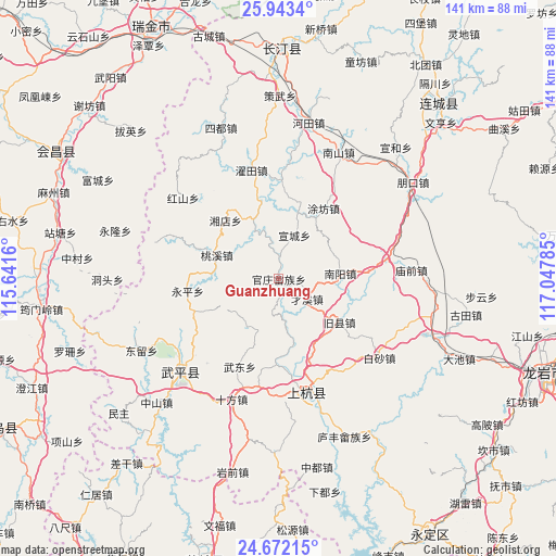
| Upper-left | 25.9434°, | 115.6416° |
| Center: | 25.30944°, | 116.34472° |
| Lower-right: | 24.67215°, | 117.04785° |
| Map W x H: | 141.3×141.4 km | = 87.8×87.9mi |
| max Lat: | 53.31946° ⇑85.1% North |
| Guanzhuang: | 25.30944° |
| min Lat: | ⇓14.9% South 18.22056° |
| min Long | Guanzhuang | max Long |
| 75.07348° | 116.34472° | 134.28917° |
| W 62.1%⇐ | ⇒37.9% E |
Elevation
Elevation of Guanzhuang is 239 m = 784 ft, and this is 245.8 m = 806 ft below average elevation for this country.
| Max E: |
5622 m = 18445 ft | 41.7% |
| Avg. | 484.8 m = 1591 ft | |
| Guanzhuang | 239 m = 784 ft | |
Min E: |
-3 m = -10 ft | 58.3% |
See also: China elevation on elevation.city.
Geographical zone
Guanzhuang is located in North temperate zone (between Tropic of Cancer and the Arctic Circle). Distance of this Northern Tropic circle is 208.2 km =129.4 mi to South.| Distance of | km | miles | from Guanzhuang |
|---|---|---|---|
| North Pole | 7192.9 | 4469.5 | to North |
| Arctic Circle | 4587 | 2850.2 | to North |
| Tropic Cancer | 208.2 | 129.4 | to South |
| Equator | 2814.1 | 1748.6 | to South |


Nearby cities:
15 places around Guanzhuang: (largest is in red/bold)
• Dahe
26.5 km =16.5 mi,  292°
292°
• Jiuxian
18.1 km =11.2 mi,  121°
121°
• Shangcai Zhongxing
8.8 km =5.5 mi,  125°
125°
• Shanhu
8.9 km =5.5 mi,  191°
191°
• Shaxiaba
15.7 km =9.8 mi,  84°
84°
• Taoxi
17 km =10.6 mi, 290°
• Tongxian
11.3 km =7 mi,  94°
94°
• Tufang
21.3 km =13.2 mi,  32°
32°
• Wudong
24.4 km =15.2 mi,  204°
204°
• Xiangdian
20.2 km =12.6 mi,  317°
317°
• Xinquan
27.3 km =17 mi, 79°
• Xuancheng
11.8 km =7.3 mi,  19°
19°
• Yanggu
9 km =5.6 mi,  341°
341°
• Yongping
23.4 km =14.5 mi,  262°
262°
• Zhongbao
15 km =9.3 mi,  212°
212°
Sources, notices
• [Note1] Compared only with cities in China existing in our database
• [Src1] Map data: © OpenStreetMap contributors (CC-BY-SA)
• [Src2] Other city data from geonames.org with taken over terms of usage.
• [Src3] Geographical zone / Annual Mean Temperature by Robert A. Rohde @ Wikipedia
