Shangcai Zhongxing geodata
Shangcai Zhongxing (Fujian) is a seat of a fourth-order administrative division; located in China in Asia/Shanghai (GMT+8) time zone. In our database, there are 1268 cities with bigger population. Compared to other cities in China, 85.3% of cities are located further ↑North; 62.6% of cities are located further ←West and 69.2% of cities have lower elevation than Shangcai Zhongxing. Note1


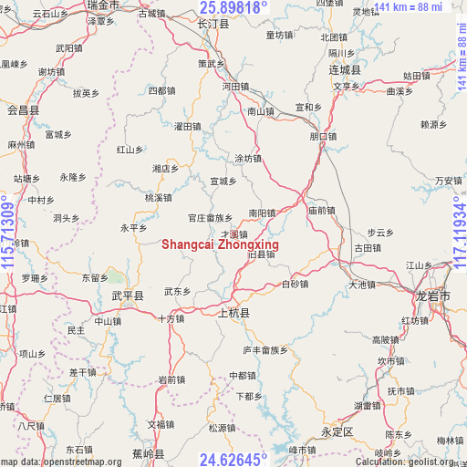
Shangcai Zhongxing GPS coordinates[2]
25° 15' 50.328" North, 116° 24' 58.356" East
| Map corner | latitude | longitude |
|---|---|---|
| Upper-left | 25.89818°, | 115.71309° |
| Center: | 25.26398°, | 116.41621° |
| Lower-right: | 24.62645°, | 117.11934° |
| Map W x H: | 141.4×141.4 km | = 87.9×87.9mi |
| max Lat: | 53.31946° ⇑85.3% North |
| Shangcai Zhongxing: | 25.26398° |
| min Lat: | ⇓14.7% South 18.22056° |
| min Long | Shangcai Zhongx | max Long |
| 75.07348° | 116.41621° | 134.28917° |
| W 62.6%⇐ | ⇒37.4% E |
Elevation
Elevation of Shangcai Zhongxing is 396 m = 1299 ft, and this is 88.8 m = 291 ft below average elevation for this country.
| Max E: |
5622 m = 18445 ft | 30.8% |
| Avg. | 484.8 m = 1591 ft | |
| Shangcai Zhongxing | 396 m = 1299 ft | |
Min E: |
-3 m = -10 ft | 69.2% |
See also: China elevation on elevation.city.
Geographical zone
Shangcai Zhongxing is located in North temperate zone (between Tropic of Cancer and the Arctic Circle). Distance of this Northern Tropic circle is 203.2 km =126.3 mi to South.| Distance of | km | miles | from Shangcai Zhongxing |
|---|---|---|---|
| North Pole | 7198 | 4472.6 | to North |
| Arctic Circle | 4592.1 | 2853.4 | to North |
| Tropic Cancer | 203.2 | 126.3 | to South |
| Equator | 2809.1 | 1745.5 | to South |


Nearby cities:
15 places around Shangcai Zhongxing: (largest is in red/bold)
• Baisha
23.7 km =14.7 mi,  129°
129°
• Guanzhuang
8.8 km =5.5 mi,  305°
305°
• Jiuxian
9.3 km =5.8 mi,  118°
118°
• Lincheng
22.8 km =14.2 mi,  182°
182°
• Linjiang
23.6 km =14.7 mi, 179°
• Shanhu
9.7 km =6 mi,  247°
247°
• Shaxiaba
10.7 km =6.6 mi,  52°
52°
• Taoxi
25.6 km =15.9 mi,  295°
295°
• Tongxian
5.8 km =3.6 mi,  43°
43°
• Tufang
23.4 km =14.5 mi,  10°
10°
• Wudong
24.3 km =15.1 mi,  224°
224°
• Xinquan
22.1 km =13.7 mi,  62°
62°
• Xuancheng
16.5 km =10.3 mi,  348°
348°
• Yanggu
16.9 km =10.5 mi,  323°
323°
• Zhongbao
17 km =10.6 mi,  243°
243°
Sources, notices
• [Note1] Compared only with cities in China existing in our database
• [Src1] Map data: © OpenStreetMap contributors (CC-BY-SA)
• [Src2] Other city data from geonames.org with taken over terms of usage.
• [Src3] Geographical zone / Annual Mean Temperature by Robert A. Rohde @ Wikipedia
