Jinsha geodata
Jinsha (Fujian) is a seat of a fourth-order administrative division; located in China in Asia/Shanghai (GMT+8) time zone. In our database, there are 1268 cities with bigger population. Compared to other cities in China, 81.6% of cities are located further ↑North; 74.5% of cities are located further ←West and 52.4% of cities have higher elevation than Jinsha. Note1


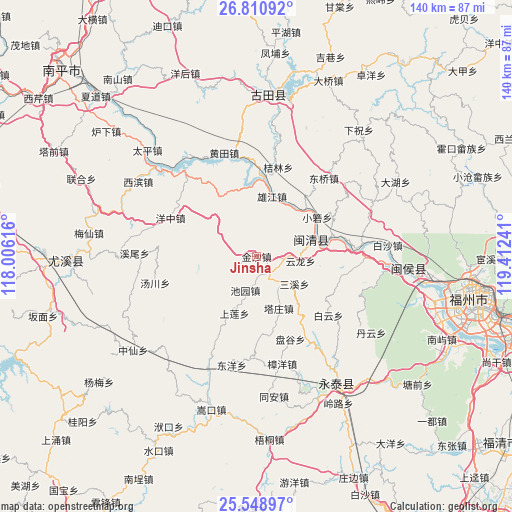
Jinsha GPS coordinates[2]
26° 10' 53.94" North, 118° 42' 33.408" East
| Map corner | latitude | longitude |
|---|---|---|
| Upper-left | 26.81092°, | 118.00616° |
| Center: | 26.18165°, | 118.70928° |
| Lower-right: | 25.54897°, | 119.41241° |
| Map W x H: | 140.3×140.3 km | = 87.2×87.2mi |
| max Lat: | 53.31946° ⇑81.6% North |
| Jinsha: | 26.18165° |
| min Lat: | ⇓18.4% South 18.22056° |
| min Long | Jinsha | max Long |
| 75.07348° | 118.70928° | 134.28917° |
| W 74.5%⇐ | ⇒25.5% E |
Elevation
Elevation of Jinsha is 147 m = 482 ft, and this is 337.8 m = 1108 ft below average elevation for this country.
| Max E: |
5622 m = 18445 ft | 52.4% |
| Avg. | 484.8 m = 1591 ft | |
| Jinsha | 147 m = 482 ft | |
Min E: |
-3 m = -10 ft | 47.6% |
See also: China elevation on elevation.city.
Geographical zone
Jinsha is located in North temperate zone (between Tropic of Cancer and the Arctic Circle). Distance of this Northern Tropic circle is 305.2 km =189.6 mi to South.| Distance of | km | miles | from Jinsha |
|---|---|---|---|
| North Pole | 7095.9 | 4409.2 | to North |
| Arctic Circle | 4490 | 2790 | to North |
| Tropic Cancer | 305.2 | 189.6 | to South |
| Equator | 2911.1 | 1808.9 | to South |


Nearby cities:
15 places around Jinsha: (largest is in red/bold)
• Baizhang
9.7 km =6 mi,  89°
89°
• Baizhong
5.8 km =3.6 mi,  150°
150°
• Bandong
9.7 km =6 mi,  142°
142°
• Chiyuan
9.8 km =6.1 mi,  198°
198°
• Jiatou
19 km =11.8 mi,  212°
212°
• Meicheng
15.6 km =9.7 mi,  76°
76°
• Meipu
18.9 km =11.7 mi, 79°
• Meixi
17.2 km =10.7 mi, 79°
• Sanxi
12.8 km =8 mi,  126°
126°
• Shanglian
16.7 km =10.4 mi, 201°
• Shenghuang
21.7 km =13.5 mi,  176°
176°
• Tazhuang
15.5 km =9.6 mi,  156°
156°
• Xiaoruo
19.5 km =12.1 mi,  56°
56°
• Xiongjiang
17.4 km =10.8 mi,  10°
10°
• Yunlong
12.1 km =7.5 mi,  95°
95°
Sources, notices
• [Note1] Compared only with cities in China existing in our database
• [Src1] Map data: © OpenStreetMap contributors (CC-BY-SA)
• [Src2] Other city data from geonames.org with taken over terms of usage.
• [Src3] Geographical zone / Annual Mean Temperature by Robert A. Rohde @ Wikipedia
