Chiyuan geodata
Chiyuan (Fujian) is a seat of a fourth-order administrative division; located in China in Asia/Shanghai (GMT+8) time zone. In our database, there are 1268 cities with bigger population. Compared to other cities in China, 82% of cities are located further ↑North; 74.3% of cities are located further ←West and 56.2% of cities have lower elevation than Chiyuan. Note1


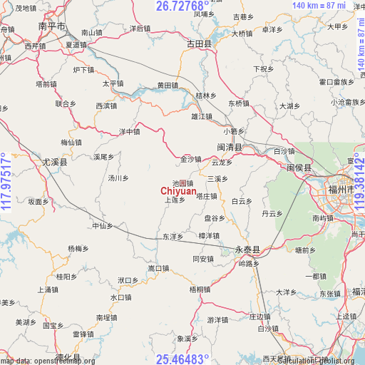
Chiyuan GPS coordinates[2]
26° 5' 52.656" North, 118° 40' 41.844" East
| Map corner | latitude | longitude |
|---|---|---|
| Upper-left | 26.72768°, | 117.97517° |
| Center: | 26.09796°, | 118.67829° |
| Lower-right: | 25.46483°, | 119.38142° |
| Map W x H: | 140.4×140.4 km | = 87.2×87.2mi |
| max Lat: | 53.31946° ⇑82% North |
| Chiyuan: | 26.09796° |
| min Lat: | ⇓18% South 18.22056° |
| min Long | Chiyuan | max Long |
| 75.07348° | 118.67829° | 134.28917° |
| W 74.3%⇐ | ⇒25.7% E |
Elevation
Elevation of Chiyuan is 218 m = 715 ft, and this is 266.8 m = 875 ft below average elevation for this country.
| Max E: |
5622 m = 18445 ft | 43.8% |
| Avg. | 484.8 m = 1591 ft | |
| Chiyuan | 218 m = 715 ft | |
Min E: |
-3 m = -10 ft | 56.2% |
See also: China elevation on elevation.city.
Geographical zone
Chiyuan is located in North temperate zone (between Tropic of Cancer and the Arctic Circle). Distance of this Northern Tropic circle is 295.9 km =183.9 mi to South.| Distance of | km | miles | from Chiyuan |
|---|---|---|---|
| North Pole | 7105.2 | 4415 | to North |
| Arctic Circle | 4499.4 | 2795.8 | to North |
| Tropic Cancer | 295.9 | 183.9 | to South |
| Equator | 2901.8 | 1803.1 | to South |


Nearby cities:
15 places around Chiyuan: (largest is in red/bold)
• Baizhang
15.8 km =9.8 mi,  53°
53°
• Baizhong
7.3 km =4.5 mi, 54°
• Bandong
9.1 km =5.7 mi,  79°
79°
• Dongyang
20.8 km =12.9 mi,  190°
190°
• Hongxing
19.7 km =12.2 mi,  126°
126°
• Houjia
14.6 km =9.1 mi,  242°
242°
• Jiatou
9.8 km =6.1 mi,  225°
225°
• Jinsha
9.8 km =6.1 mi,  18°
18°
• Pangu
18.2 km =11.3 mi,  137°
137°
• Sanxi
13.6 km =8.5 mi, 82°
• Shanglian
7 km =4.3 mi,  205°
205°
• Shenghuang
13.1 km =8.1 mi,  159°
159°
• Tazhuang
10.4 km =6.5 mi,  118°
118°
• Xiaba
18.9 km =11.7 mi,  176°
176°
• Yunlong
17.2 km =10.7 mi,  61°
61°
Sources, notices
• [Note1] Compared only with cities in China existing in our database
• [Src1] Map data: © OpenStreetMap contributors (CC-BY-SA)
• [Src2] Other city data from geonames.org with taken over terms of usage.
• [Src3] Geographical zone / Annual Mean Temperature by Robert A. Rohde @ Wikipedia
