Meipu geodata
Meipu (Fujian) is a populated place; located in China in Asia/Shanghai (GMT+8) time zone. With population of 1,930 people, there are 1040 cities with bigger population in this country. Compared to other cities in China, 81.5% of cities are located further ↑North; 75.5% of cities are located further ←West and 70% of cities have higher elevation than Meipu. Note1


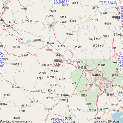
Meipu GPS coordinates[2]
26° 12' 40.32" North, 118° 53' 44.196" East
| Map corner | latitude | longitude |
|---|---|---|
| Upper-left | 26.8403°, | 118.19249° |
| Center: | 26.2112°, | 118.89561° |
| Lower-right: | 25.57868°, | 119.59874° |
| Map W x H: | 140.3×140.3 km | = 87.2×87.2mi |
| max Lat: | 53.31946° ⇑81.5% North |
| Meipu: | 26.2112° |
| min Lat: | ⇓18.5% South 18.22056° |
| min Long | Meipu | max Long |
| 75.07348° | 118.89561° | 134.28917° |
| W 75.5%⇐ | ⇒24.5% E |
Elevation
Elevation of Meipu is 52 m = 171 ft, and this is 432.8 m = 1420 ft below average elevation for this country.
| Max E: |
5622 m = 18445 ft | 70% |
| Avg. | 484.8 m = 1591 ft | |
| Meipu | 52 m = 171 ft | |
Min E: |
-3 m = -10 ft | 30% |
See also: China elevation on elevation.city.
Geographical zone
Meipu is located in North temperate zone (between Tropic of Cancer and the Arctic Circle). Distance of this Northern Tropic circle is 308.5 km =191.7 mi to South.| Distance of | km | miles | from Meipu |
|---|---|---|---|
| North Pole | 7092.6 | 4407.1 | to North |
| Arctic Circle | 4486.8 | 2788 | to North |
| Tropic Cancer | 308.5 | 191.7 | to South |
| Equator | 2914.4 | 1810.9 | to South |


Nearby cities:
15 places around Meipu: (largest is in red/bold)
• Baisha
17.3 km =10.7 mi,  90°
90°
• Baiyun
19.5 km =12.1 mi,  176°
176°
• Baizhang
9.5 km =5.9 mi,  249°
249°
• Baizhong
17.8 km =11.1 mi,  242°
242°
• Bandong
16.9 km =10.5 mi,  229°
229°
• Daping
17.8 km =11.1 mi,  48°
48°
• Dongqiao
17.8 km =11.1 mi,  358°
358°
• Hongwei
11.1 km =6.9 mi,  115°
115°
• Jinsha
18.9 km =11.7 mi,  259°
259°
• Meicheng
3.5 km =2.2 mi,  277°
277°
• Meixi
1.7 km =1.1 mi, 262°
• Sanxi
13.6 km =8.5 mi,  217°
217°
• Xiaoruo
7.7 km =4.8 mi,  342°
342°
• Yangli
18.1 km =11.2 mi,  19°
19°
• Yunlong
7.9 km =4.9 mi, 235°
Sources, notices
• [Note1] Compared only with cities in China existing in our database
• [Src1] Map data: © OpenStreetMap contributors (CC-BY-SA)
• [Src2] Other city data from geonames.org with taken over terms of usage.
• [Src3] Geographical zone / Annual Mean Temperature by Robert A. Rohde @ Wikipedia
