Yunlong geodata
Yunlong (Fujian) is a seat of a fourth-order administrative division; located in China in Asia/Shanghai (GMT+8) time zone. In our database, there are 1268 cities with bigger population. Compared to other cities in China, 81.7% of cities are located further ↑North; 75.1% of cities are located further ←West and 69.5% of cities have higher elevation than Yunlong. Note1


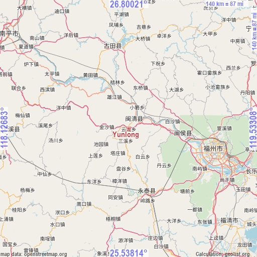
Yunlong GPS coordinates[2]
26° 10' 15.168" North, 118° 49' 47.82" East
| Map corner | latitude | longitude |
|---|---|---|
| Upper-left | 26.80021°, | 118.12683° |
| Center: | 26.17088°, | 118.82995° |
| Lower-right: | 25.53814°, | 119.53308° |
| Map W x H: | 140.3×140.3 km | = 87.2×87.2mi |
| max Lat: | 53.31946° ⇑81.7% North |
| Yunlong: | 26.17088° |
| min Lat: | ⇓18.3% South 18.22056° |
| min Long | Yunlong | max Long |
| 75.07348° | 118.82995° | 134.28917° |
| W 75.1%⇐ | ⇒24.9% E |
Elevation
Elevation of Yunlong is 54 m = 177 ft, and this is 430.8 m = 1413 ft below average elevation for this country.
| Max E: |
5622 m = 18445 ft | 69.5% |
| Avg. | 484.8 m = 1591 ft | |
| Yunlong | 54 m = 177 ft | |
Min E: |
-3 m = -10 ft | 30.5% |
See also: China elevation on elevation.city.
Geographical zone
Yunlong is located in North temperate zone (between Tropic of Cancer and the Arctic Circle). Distance of this Northern Tropic circle is 304 km =188.9 mi to South.| Distance of | km | miles | from Yunlong |
|---|---|---|---|
| North Pole | 7097.1 | 4409.9 | to North |
| Arctic Circle | 4491.2 | 2790.7 | to North |
| Tropic Cancer | 304 | 188.9 | to South |
| Equator | 2909.9 | 1808.1 | to South |


Nearby cities:
15 places around Yunlong: (largest is in red/bold)
• Baiyun
16.8 km =10.4 mi,  152°
152°
• Baizhang
2.6 km =1.6 mi,  297°
297°
• Baizhong
10 km =6.2 mi,  247°
247°
• Bandong
9 km =5.6 mi,  223°
223°
• Chiyuan
17.2 km =10.7 mi,  241°
241°
• Hongwei
16.6 km =10.3 mi,  90°
90°
• Hongxing
19.7 km =12.2 mi,  177°
177°
• Jinsha
12.1 km =7.5 mi,  275°
275°
• Meicheng
5.8 km =3.6 mi,  32°
32°
• Meipu
7.9 km =4.9 mi,  55°
55°
• Meixi
6.5 km =4 mi,  48°
48°
• Sanxi
6.6 km =4.1 mi,  194°
194°
• Tazhuang
14.3 km =8.9 mi,  204°
204°
• Xiaoruo
12.6 km =7.8 mi,  19°
19°
• Xiongjiang
20.2 km =12.6 mi,  334°
334°
Sources, notices
• [Note1] Compared only with cities in China existing in our database
• [Src1] Map data: © OpenStreetMap contributors (CC-BY-SA)
• [Src2] Other city data from geonames.org with taken over terms of usage.
• [Src3] Geographical zone / Annual Mean Temperature by Robert A. Rohde @ Wikipedia
