Jinji geodata
Jinji (Anhui) is a seat of a fourth-order administrative division; located in China in Asia/Shanghai (GMT+8) time zone. In our database, there are 1268 cities with bigger population. Compared to other cities in China, 64.3% of cities are located further ↓South; 76.4% of cities are located further ←West and 69.7% of cities have higher elevation than Jinji. Note1


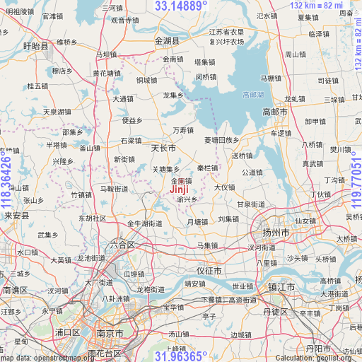
Jinji GPS coordinates[2]
32° 33' 29.628" North, 119° 4' 2.568" East
| Map corner | latitude | longitude |
|---|---|---|
| Upper-left | 33.14889°, | 118.36426° |
| Center: | 32.55823°, | 119.06738° |
| Lower-right: | 31.96365°, | 119.77051° |
| Map W x H: | 131.8×131.8 km | = 81.9×81.9mi |
| max Lat: | 53.31946° ⇑35.7% North |
| Jinji: | 32.55823° |
| min Lat: | ⇓64.3% South 18.22056° |
| min Long | Jinji | max Long |
| 75.07348° | 119.06738° | 134.28917° |
| W 76.4%⇐ | ⇒23.6% E |
Elevation
Elevation of Jinji is 53 m = 174 ft, and this is 431.8 m = 1417 ft below average elevation for this country.
| Max E: |
5622 m = 18445 ft | 69.7% |
| Avg. | 484.8 m = 1591 ft | |
| Jinji | 53 m = 174 ft | |
Min E: |
-3 m = -10 ft | 30.3% |
See also: China elevation on elevation.city.
Geographical zone
Jinji is located in North temperate zone (between Tropic of Cancer and the Arctic Circle). Distance of this Northern Tropic circle is 1014.2 km =630.2 mi to South.| Distance of | km | miles | from Jinji |
|---|---|---|---|
| North Pole | 6386.9 | 3968.6 | to North |
| Arctic Circle | 3781 | 2349.4 | to North |
| Tropic Cancer | 1014.2 | 630.2 | to South |
| Equator | 3620.1 | 2249.4 | to South |


Nearby cities:
15 places around Jinji: (largest is in red/bold)
• Babaiqiao
20.1 km =12.5 mi,  220°
220°
• Chenji
13.7 km =8.5 mi,  126°
126°
• Dayi
16.1 km =10 mi,  96°
96°
• Jiepai
17.4 km =10.8 mi,  26°
26°
• Qinlan
10.4 km =6.5 mi,  62°
62°
• Renheji
8.8 km =5.5 mi, 30°
• Tianchang
15.1 km =9.4 mi,  338°
338°
• Tianshan
18.4 km =11.4 mi,  66°
66°
• Wanshou
18.7 km =11.6 mi,  3°
3°
• Xieji
15.9 km =9.9 mi,  157°
157°
• Yeshan
7.5 km =4.7 mi,  315°
315°
• Yeshan
15.2 km =9.4 mi,  251°
251°
• Yongfeng
20.5 km =12.7 mi, 339°
• Yuetang
17.1 km =10.6 mi,  175°
175°
• Zhengji
12.1 km =7.5 mi,  290°
290°
Sources, notices
• [Note1] Compared only with cities in China existing in our database
• [Src1] Map data: © OpenStreetMap contributors (CC-BY-SA)
• [Src2] Other city data from geonames.org with taken over terms of usage.
• [Src3] Geographical zone / Annual Mean Temperature by Robert A. Rohde @ Wikipedia
