Chenji geodata
Chenji (Jiangsu) is a seat of a fourth-order administrative division; located in China in Asia/Shanghai (GMT+8) time zone. In our database, there are 1268 cities with bigger population. Compared to other cities in China, 63.9% of cities are located further ↓South; 77% of cities are located further ←West and 73.7% of cities have higher elevation than Chenji. Note1


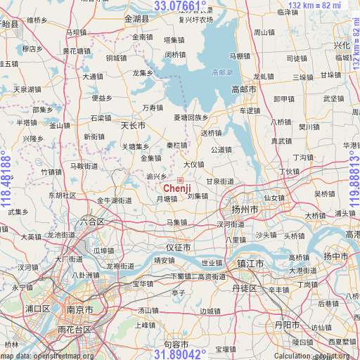
Chenji GPS coordinates[2]
32° 29' 7.692" North, 119° 11' 6" East
| Map corner | latitude | longitude |
|---|---|---|
| Upper-left | 33.07661°, | 118.48188° |
| Center: | 32.48547°, | 119.185° |
| Lower-right: | 31.89042°, | 119.88813° |
| Map W x H: | 131.9×131.9 km | = 82×82mi |
| max Lat: | 53.31946° ⇑36.1% North |
| Chenji: | 32.48547° |
| min Lat: | ⇓63.9% South 18.22056° |
| min Long | Chenji | max Long |
| 75.07348° | 119.185° | 134.28917° |
| W 77%⇐ | ⇒23% E |
Elevation
Elevation of Chenji is 40 m = 131 ft, and this is 444.8 m = 1459 ft below average elevation for this country.
| Max E: |
5622 m = 18445 ft | 73.7% |
| Avg. | 484.8 m = 1591 ft | |
| Chenji | 40 m = 131 ft | |
Min E: |
-3 m = -10 ft | 26.3% |
See also: China elevation on elevation.city.
Geographical zone
Chenji is located in North temperate zone (between Tropic of Cancer and the Arctic Circle). Distance of this Northern Tropic circle is 1006.1 km =625.2 mi to South.| Distance of | km | miles | from Chenji |
|---|---|---|---|
| North Pole | 6395 | 3973.7 | to North |
| Arctic Circle | 3789.1 | 2354.4 | to North |
| Tropic Cancer | 1006.1 | 625.2 | to South |
| Equator | 3612 | 2244.4 | to South |


Nearby cities:
15 places around Chenji: (largest is in red/bold)
• Dayi
8.1 km =5 mi,  38°
38°
• Fangxiang
19 km =11.8 mi,  83°
83°
• Ganquan
14.8 km =9.2 mi,  92°
92°
• Gongdao
19.1 km =11.9 mi,  52°
52°
• Jinji
13.7 km =8.5 mi,  306°
306°
• Liuji
8.4 km =5.2 mi,  132°
132°
• Maji
14.7 km =9.1 mi,  186°
186°
• Qinlan
13 km =8.1 mi,  352°
352°
• Renheji
17 km =10.6 mi,  337°
337°
• Tianshan
16.5 km =10.3 mi,  21°
21°
• Xieji
8.3 km =5.2 mi,  217°
217°
• Xihu
20.7 km =12.9 mi,  108°
108°
• Xinji
20.2 km =12.6 mi,  149°
149°
• Yangmiao
15.6 km =9.7 mi,  119°
119°
• Yuetang
13.3 km =8.3 mi,  227°
227°
Sources, notices
• [Note1] Compared only with cities in China existing in our database
• [Src1] Map data: © OpenStreetMap contributors (CC-BY-SA)
• [Src2] Other city data from geonames.org with taken over terms of usage.
• [Src3] Geographical zone / Annual Mean Temperature by Robert A. Rohde @ Wikipedia
