Xieji geodata
Xieji (Jiangsu) is a seat of a fourth-order administrative division; located in China in Asia/Shanghai (GMT+8) time zone. In our database, there are 1268 cities with bigger population. Compared to other cities in China, 63.7% of cities are located further ↓South; 76.7% of cities are located further ←West and 70.5% of cities have higher elevation than Xieji. Note1


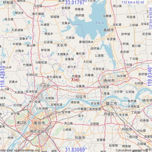
Xieji GPS coordinates[2]
32° 25' 34.068" North, 119° 7' 53.292" East
| Map corner | latitude | longitude |
|---|---|---|
| Upper-left | 33.01767°, | 118.42835° |
| Center: | 32.42613°, | 119.13147° |
| Lower-right: | 31.83069°, | 119.8346° |
| Map W x H: | 132×132 km | = 82×82mi |
| max Lat: | 53.31946° ⇑36.3% North |
| Xieji: | 32.42613° |
| min Lat: | ⇓63.7% South 18.22056° |
| min Long | Xieji | max Long |
| 75.07348° | 119.13147° | 134.28917° |
| W 76.7%⇐ | ⇒23.3% E |
Elevation
Elevation of Xieji is 50 m = 164 ft, and this is 434.8 m = 1427 ft below average elevation for this country.
| Max E: |
5622 m = 18445 ft | 70.5% |
| Avg. | 484.8 m = 1591 ft | |
| Xieji | 50 m = 164 ft | |
Min E: |
-3 m = -10 ft | 29.5% |
See also: China elevation on elevation.city.
Geographical zone
Xieji is located in North temperate zone (between Tropic of Cancer and the Arctic Circle). Distance of this Northern Tropic circle is 999.5 km =621.1 mi to South.| Distance of | km | miles | from Xieji |
|---|---|---|---|
| North Pole | 6401.6 | 3977.8 | to North |
| Arctic Circle | 3795.7 | 2358.5 | to North |
| Tropic Cancer | 999.5 | 621.1 | to South |
| Equator | 3605.4 | 2240.3 | to South |


Nearby cities:
15 places around Xieji: (largest is in red/bold)
• Babaiqiao
19.1 km =11.9 mi,  268°
268°
• Chenji
8.3 km =5.2 mi,  37°
37°
• Dayi
16.4 km =10.2 mi, 37°
• Ganquan
20.7 km =12.9 mi,  72°
72°
• Jinji
15.9 km =9.9 mi,  337°
337°
• Liuji
11.2 km =7 mi,  85°
85°
• Maji
8.6 km =5.3 mi,  157°
157°
• Qingshan
20.1 km =12.5 mi,  195°
195°
• Qinlan
19.8 km =12.3 mi,  9°
9°
• Xincheng
18.1 km =11.2 mi,  148°
148°
• Xinhuang
18.9 km =11.7 mi,  252°
252°
• Xinji
18.7 km =11.6 mi,  125°
125°
• Yangmiao
18.6 km =11.6 mi, 93°
• Yuetang
5.4 km =3.4 mi,  243°
243°
• Zhenzhou
16.6 km =10.3 mi,  167°
167°
Sources, notices
• [Note1] Compared only with cities in China existing in our database
• [Src1] Map data: © OpenStreetMap contributors (CC-BY-SA)
• [Src2] Other city data from geonames.org with taken over terms of usage.
• [Src3] Geographical zone / Annual Mean Temperature by Robert A. Rohde @ Wikipedia
