Jingxi geodata
Jingxi (Fujian) is a seat of a fourth-order administrative division; located in China in Asia/Shanghai (GMT+8) time zone. In our database, there are 1268 cities with bigger population. Compared to other cities in China, 81.5% of cities are located further ↑North; 68.9% of cities are located further ←West and 52.5% of cities have lower elevation than Jingxi. Note1


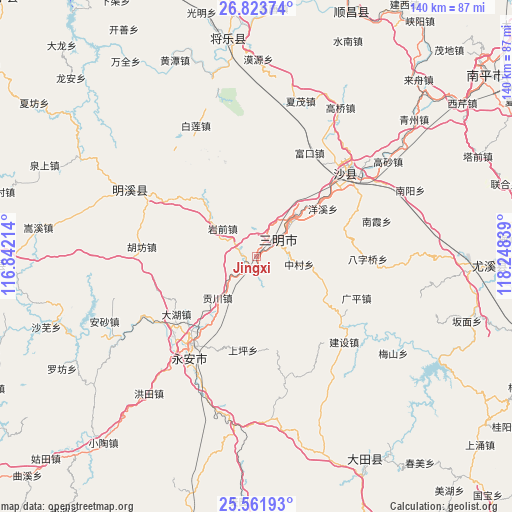
Jingxi GPS coordinates[2]
26° 11' 40.344" North, 117° 32' 42.936" East
| Map corner | latitude | longitude |
|---|---|---|
| Upper-left | 26.82374°, | 116.84214° |
| Center: | 26.19454°, | 117.54526° |
| Lower-right: | 25.56193°, | 118.24839° |
| Map W x H: | 140.3×140.3 km | = 87.2×87.2mi |
| max Lat: | 53.31946° ⇑81.5% North |
| Jingxi: | 26.19454° |
| min Lat: | ⇓18.5% South 18.22056° |
| min Long | Jingxi | max Long |
| 75.07348° | 117.54526° | 134.28917° |
| W 68.9%⇐ | ⇒31.1% E |
Elevation
Elevation of Jingxi is 184 m = 604 ft, and this is 300.8 m = 987 ft below average elevation for this country.
| Max E: |
5622 m = 18445 ft | 47.5% |
| Avg. | 484.8 m = 1591 ft | |
| Jingxi | 184 m = 604 ft | |
Min E: |
-3 m = -10 ft | 52.5% |
See also: China elevation on elevation.city.
Geographical zone
Jingxi is located in North temperate zone (between Tropic of Cancer and the Arctic Circle). Distance of this Northern Tropic circle is 306.6 km =190.5 mi to South.| Distance of | km | miles | from Jingxi |
|---|---|---|---|
| North Pole | 7094.5 | 4408.3 | to North |
| Arctic Circle | 4488.6 | 2789.1 | to North |
| Tropic Cancer | 306.6 | 190.5 | to South |
| Equator | 2912.6 | 1809.8 | to South |


Nearby cities:
15 places around Jingxi: (largest is in red/bold)
• Chenda
16.6 km =10.3 mi,  36°
36°
• Chengdong
9.3 km =5.8 mi,  52°
52°
• Dahu
27.4 km =17 mi,  233°
233°
• Daluo
25.1 km =15.6 mi,  75°
75°
• Gongchuan
15.7 km =9.8 mi,  223°
223°
• Huyuan
23.5 km =14.6 mi,  107°
107°
• Sanming
9.5 km =5.9 mi, 50°
• Shangping
26 km =16.2 mi,  188°
188°
• Shaxi
25.1 km =15.6 mi,  308°
308°
• Shenkou
3.5 km =2.2 mi, 194°
• Xiayang
27.6 km =17.1 mi,  340°
340°
• Xubi
12.9 km =8 mi, 42°
• Yangxi
22.3 km =13.9 mi, 54°
• Yanqian
12 km =7.5 mi, 309°
• Zhongcun
11.8 km =7.3 mi,  100°
100°
Sources, notices
• [Note1] Compared only with cities in China existing in our database
• [Src1] Map data: © OpenStreetMap contributors (CC-BY-SA)
• [Src2] Other city data from geonames.org with taken over terms of usage.
• [Src3] Geographical zone / Annual Mean Temperature by Robert A. Rohde @ Wikipedia
