Jingnao geodata
Jingnao (Jiangxi) is a seat of a fourth-order administrative division; located in China in Asia/Shanghai (GMT+8) time zone. In our database, there are 1268 cities with bigger population. Compared to other cities in China, 86.3% of cities are located further ↑North; 54.5% of cities are located further ←West and 67.8% of cities have lower elevation than Jingnao. Note1


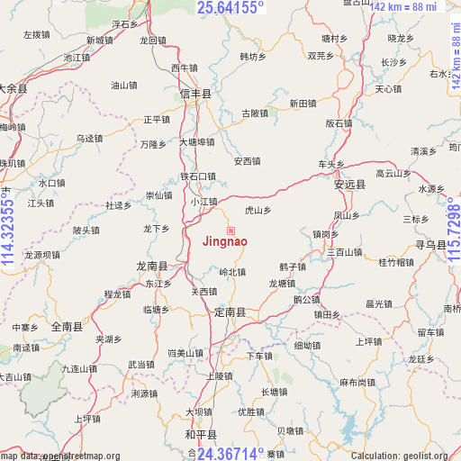
Jingnao GPS coordinates[2]
25° 0' 21.6" North, 115° 1' 36.012" East
| Map corner | latitude | longitude |
|---|---|---|
| Upper-left | 25.64155°, | 114.32355° |
| Center: | 25.006°, | 115.02667° |
| Lower-right: | 24.36714°, | 115.7298° |
| Map W x H: | 141.7×141.7 km | = 88×88mi |
| max Lat: | 53.31946° ⇑86.3% North |
| Jingnao: | 25.006° |
| min Lat: | ⇓13.7% South 18.22056° |
| min Long | Jingnao | max Long |
| 75.07348° | 115.02667° | 134.28917° |
| W 54.5%⇐ | ⇒45.5% E |
Elevation
Elevation of Jingnao is 374 m = 1227 ft, and this is 110.8 m = 364 ft below average elevation for this country.
| Max E: |
5622 m = 18445 ft | 32.2% |
| Avg. | 484.8 m = 1591 ft | |
| Jingnao | 374 m = 1227 ft | |
Min E: |
-3 m = -10 ft | 67.8% |
See also: China elevation on elevation.city.
Geographical zone
Jingnao is located in North temperate zone (between Tropic of Cancer and the Arctic Circle). Distance of this Northern Tropic circle is 174.5 km =108.4 mi to South.| Distance of | km | miles | from Jingnao |
|---|---|---|---|
| North Pole | 7226.7 | 4490.5 | to North |
| Arctic Circle | 4620.8 | 2871.2 | to North |
| Tropic Cancer | 174.5 | 108.4 | to South |
| Equator | 2780.4 | 1727.7 | to South |


Nearby cities:
15 places around Jingnao: (largest is in red/bold)
• Anxi
22.4 km =13.9 mi,  12°
12°
• Fengshan
36 km =22.4 mi,  81°
81°
• Guanxi
20.2 km =12.6 mi,  204°
204°
• Hushan
10.8 km =6.7 mi,  50°
50°
• Kongtian
29.5 km =18.3 mi,  107°
107°
• Laocheng
35.6 km =22.1 mi,  186°
186°
• Lintang
33.3 km =20.7 mi,  224°
224°
• Liren
19.1 km =11.9 mi,  231°
231°
• Lishi
22.4 km =13.9 mi,  178°
178°
• Longnan
27.2 km =16.9 mi,  244°
244°
• Sanbaishan
35.3 km =21.9 mi,  100°
100°
• Taojiang
26.8 km =16.7 mi,  248°
248°
• Wenlong
29.5 km =18.3 mi,  205°
205°
• Xinlong
34 km =21.1 mi,  62°
62°
• Zhengang
29.1 km =18.1 mi,  91°
91°
Sources, notices
• [Note1] Compared only with cities in China existing in our database
• [Src1] Map data: © OpenStreetMap contributors (CC-BY-SA)
• [Src2] Other city data from geonames.org with taken over terms of usage.
• [Src3] Geographical zone / Annual Mean Temperature by Robert A. Rohde @ Wikipedia
