Kongtian geodata
Kongtian (Jiangxi) is a seat of a fourth-order administrative division; located in China in Asia/Shanghai (GMT+8) time zone. In our database, there are 1268 cities with bigger population. Compared to other cities in China, 86.7% of cities are located further ↑North; 55.9% of cities are located further ←West and 60.9% of cities have lower elevation than Kongtian. Note1


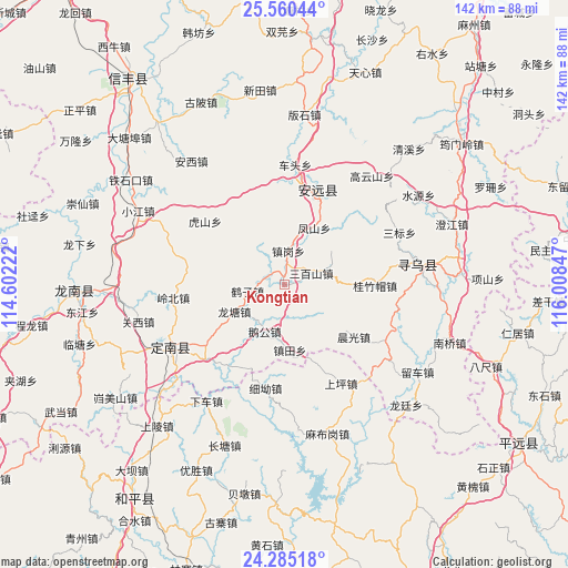
Kongtian GPS coordinates[2]
24° 55' 28.056" North, 115° 18' 19.224" East
| Map corner | latitude | longitude |
|---|---|---|
| Upper-left | 25.56044°, | 114.60222° |
| Center: | 24.92446°, | 115.30534° |
| Lower-right: | 24.28518°, | 116.00847° |
| Map W x H: | 141.8×141.8 km | = 88.1×88.1mi |
| max Lat: | 53.31946° ⇑86.7% North |
| Kongtian: | 24.92446° |
| min Lat: | ⇓13.3% South 18.22056° |
| min Long | Kongtian | max Long |
| 75.07348° | 115.30534° | 134.28917° |
| W 55.9%⇐ | ⇒44.1% E |
Elevation
Elevation of Kongtian is 269 m = 883 ft, and this is 215.8 m = 708 ft below average elevation for this country.
| Max E: |
5622 m = 18445 ft | 39.1% |
| Avg. | 484.8 m = 1591 ft | |
| Kongtian | 269 m = 883 ft | |
Min E: |
-3 m = -10 ft | 60.9% |
See also: China elevation on elevation.city.
Geographical zone
Kongtian is located in North temperate zone (between Tropic of Cancer and the Arctic Circle). Distance of this Northern Tropic circle is 165.4 km =102.8 mi to South.| Distance of | km | miles | from Kongtian |
|---|---|---|---|
| North Pole | 7235.7 | 4496.1 | to North |
| Arctic Circle | 4629.8 | 2876.8 | to North |
| Tropic Cancer | 165.4 | 102.8 | to South |
| Equator | 2771.3 | 1722 | to South |


Nearby cities:
15 places around Kongtian: (largest is in red/bold)
• Changpu
29.9 km =18.6 mi,  132°
132°
• Chenguang
21.7 km =13.5 mi, 126°
• Chetou
30.1 km =18.7 mi,  5°
5°
• Fengshan
16.1 km =10 mi,  27°
27°
• Guizhumao
22.6 km =14 mi,  90°
90°
• Hushan
25.3 km =15.7 mi,  308°
308°
• Jingnao
29.5 km =18.3 mi,  287°
287°
• Lianjiang
24.6 km =15.3 mi,  20°
20°
• Sanbaishan
7.3 km =4.5 mi,  66°
66°
• Shangping
28.4 km =17.6 mi,  150°
150°
• Xinlong
24.6 km =15.3 mi, 5°
• Xinshan
25.1 km =15.6 mi, 19°
• Xi’ao
26.3 km =16.3 mi,  189°
189°
• Zhengang
8.5 km =5.3 mi, 6°
• Zhentian
16.3 km =10.1 mi,  175°
175°
Sources, notices
• [Note1] Compared only with cities in China existing in our database
• [Src1] Map data: © OpenStreetMap contributors (CC-BY-SA)
• [Src2] Other city data from geonames.org with taken over terms of usage.
• [Src3] Geographical zone / Annual Mean Temperature by Robert A. Rohde @ Wikipedia
