Lishi geodata
Lishi (Jiangxi) is a seat of a third-order administrative division; located in China in Asia/Shanghai (GMT+8) time zone. In our database, there are 1268 cities with bigger population. Compared to other cities in China, 87.2% of cities are located further ↑North; 54.5% of cities are located further ←West and 66.1% of cities have lower elevation than Lishi. Note1


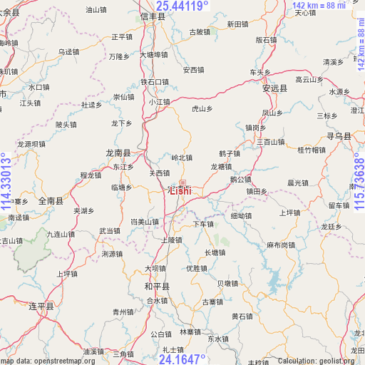
Lishi GPS coordinates[2]
24° 48' 16.524" North, 115° 1' 59.7" East
| Map corner | latitude | longitude |
|---|---|---|
| Upper-left | 25.44119°, | 114.33013° |
| Center: | 24.80459°, | 115.03325° |
| Lower-right: | 24.1647°, | 115.73638° |
| Map W x H: | 141.9×141.9 km | = 88.2×88.2mi |
| max Lat: | 53.31946° ⇑87.2% North |
| Lishi: | 24.80459° |
| min Lat: | ⇓12.8% South 18.22056° |
| min Long | Lishi | max Long |
| 75.07348° | 115.03325° | 134.28917° |
| W 54.5%⇐ | ⇒45.5% E |
Elevation
Elevation of Lishi is 346 m = 1135 ft, and this is 138.8 m = 455 ft below average elevation for this country.
| Max E: |
5622 m = 18445 ft | 33.9% |
| Avg. | 484.8 m = 1591 ft | |
| Lishi | 346 m = 1135 ft | |
Min E: |
-3 m = -10 ft | 66.1% |
See also: China elevation on elevation.city.
Geographical zone
Lishi is located in North temperate zone (between Tropic of Cancer and the Arctic Circle). Distance of this Northern Tropic circle is 152.1 km =94.5 mi to South.| Distance of | km | miles | from Lishi |
|---|---|---|---|
| North Pole | 7249.1 | 4504.4 | to North |
| Arctic Circle | 4643.2 | 2885.1 | to North |
| Tropic Cancer | 152.1 | 94.5 | to South |
| Equator | 2758 | 1713.7 | to South |


Nearby cities:
15 places around Lishi: (largest is in red/bold)
• Changtang
29.7 km =18.5 mi,  157°
157°
• Guanxi
10 km =6.2 mi,  293°
293°
• Jingnao
22.4 km =13.9 mi,  358°
358°
• Kuimeishan
21.1 km =13.1 mi,  224°
224°
• Laocheng
13.7 km =8.5 mi,  198°
198°
• Lintang
23.9 km =14.9 mi,  266°
266°
• Liren
18.8 km =11.7 mi,  303°
303°
• Longnan
27.4 km =17 mi, 292°
• Nanheng
26.4 km =16.4 mi,  244°
244°
• Shangling
23 km =14.3 mi,  190°
190°
• Taojiang
28.5 km =17.7 mi, 296°
• Wenlong
14.2 km =8.8 mi,  252°
252°
• Xiache
18.8 km =11.7 mi,  153°
153°
• Xi’ao
26.3 km =16.3 mi,  118°
118°
• Zhentian
29 km =18 mi,  95°
95°
Sources, notices
• [Note1] Compared only with cities in China existing in our database
• [Src1] Map data: © OpenStreetMap contributors (CC-BY-SA)
• [Src2] Other city data from geonames.org with taken over terms of usage.
• [Src3] Geographical zone / Annual Mean Temperature by Robert A. Rohde @ Wikipedia
