Longnan geodata
Longnan (Jiangxi) is a seat of a third-order administrative division; located in China in Asia/Shanghai (GMT+8) time zone. In our database, there are 1268 cities with bigger population. Compared to other cities in China, 86.8% of cities are located further ↑North; 53% of cities are located further ←West and 56% of cities have lower elevation than Longnan. Note1


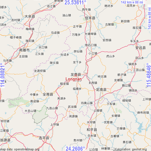
Longnan GPS coordinates[2]
24° 54' 0" North, 114° 46' 59.988" East
| Map corner | latitude | longitude |
|---|---|---|
| Upper-left | 25.53611°, | 114.08021° |
| Center: | 24.9°, | 114.78333° |
| Lower-right: | 24.2606°, | 115.48646° |
| Map W x H: | 141.8×141.8 km | = 88.1×88.1mi |
| max Lat: | 53.31946° ⇑86.8% North |
| Longnan: | 24.9° |
| min Lat: | ⇓13.2% South 18.22056° |
| min Long | Longnan | max Long |
| 75.07348° | 114.78333° | 134.28917° |
| W 53%⇐ | ⇒47% E |
Elevation
Elevation of Longnan is 216 m = 709 ft, and this is 268.8 m = 882 ft below average elevation for this country.
| Max E: |
5622 m = 18445 ft | 44% |
| Avg. | 484.8 m = 1591 ft | |
| Longnan | 216 m = 709 ft | |
Min E: |
-3 m = -10 ft | 56% |
See also: China elevation on elevation.city.
Geographical zone
Longnan is located in North temperate zone (between Tropic of Cancer and the Arctic Circle). Distance of this Northern Tropic circle is 162.7 km =101.1 mi to South.| Distance of | km | miles | from Longnan |
|---|---|---|---|
| North Pole | 7238.4 | 4497.7 | to North |
| Arctic Circle | 4632.6 | 2878.6 | to North |
| Tropic Cancer | 162.7 | 101.1 | to South |
| Equator | 2768.6 | 1720.3 | to South |


Nearby cities:
15 places around Longnan: (largest is in red/bold)
• Beitou
23 km =14.3 mi,  298°
298°
• Chenglong
13 km =8.1 mi,  235°
235°
• Dujiang
9.2 km =5.7 mi,  246°
246°
• Guanxi
17.3 km =10.7 mi,  112°
112°
• Jiahu
24.9 km =15.5 mi,  211°
211°
• Jingnao
27.2 km =16.9 mi,  64°
64°
• Jinlong
30.2 km =18.8 mi, 236°
• Kuimeishan
27.8 km =17.3 mi,  157°
157°
• Lintang
12.2 km =7.6 mi,  173°
173°
• Liren
9.6 km =6 mi,  90°
90°
• Lishi
27.4 km =17 mi, 112°
• Nanheng
22.1 km =13.7 mi,  176°
176°
• Taojiang
1.9 km =1.2 mi,  349°
349°
• Wenlong
18.8 km =11.7 mi,  141°
141°
• Wudang
29.1 km =18.1 mi,  186°
186°
Sources, notices
• [Note1] Compared only with cities in China existing in our database
• [Src1] Map data: © OpenStreetMap contributors (CC-BY-SA)
• [Src2] Other city data from geonames.org with taken over terms of usage.
• [Src3] Geographical zone / Annual Mean Temperature by Robert A. Rohde @ Wikipedia
