Jijia geodata
Jijia (Guangdong) is a seat of a fourth-order administrative division; located in China in Asia/Urumqi (GMT+6) time zone. In our database, there are 1268 cities with bigger population. Compared to other cities in China, 98.5% of cities are located further ↑North; 72.3% of cities are located further →East and 75.3% of cities have higher elevation than Jijia. Note1


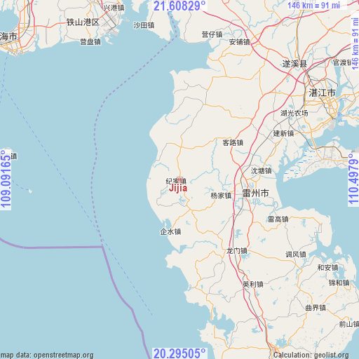
Jijia GPS coordinates[2]
20° 57' 11.196" North, 109° 47' 41.172" East
| Map corner | latitude | longitude |
|---|---|---|
| Upper-left | 21.60829°, | 109.09165° |
| Center: | 20.95311°, | 109.79477° |
| Lower-right: | 20.29505°, | 110.4979° |
| Map W x H: | 146×146 km | = 90.7×90.7mi |
| max Lat: | 53.31946° ⇑98.5% North |
| Jijia: | 20.95311° |
| min Lat: | ⇓1.5% South 18.22056° |
| min Long | Jijia | max Long |
| 75.07348° | 109.79477° | 134.28917° |
| W 27.7%⇐ | ⇒72.3% E |
Elevation
Elevation of Jijia is 36 m = 118 ft, and this is 448.8 m = 1472 ft below average elevation for this country.
| Max E: |
5622 m = 18445 ft | 75.3% |
| Avg. | 484.8 m = 1591 ft | |
| Jijia | 36 m = 118 ft | |
Min E: |
-3 m = -10 ft | 24.7% |
See also: China elevation on elevation.city.
Geographical zone
Jijia is located in North Torrid zone (between Equator and Tropic of Cancer). Distance of this Northern Tropic circle is 276.2 km =171.6 mi to North.| Distance of | km | miles | from Jijia |
|---|---|---|---|
| North Pole | 7677.3 | 4770.5 | to North |
| Arctic Circle | 5071.4 | 3151.2 | to North |
| Tropic Cancer | 276.2 | 171.6 | to North |
| Equator | 2329.8 | 1447.7 | to South |


Nearby cities:
15 places around Jijia: (largest is in red/bold)
• Baisha
31.3 km =19.4 mi,  102°
102°
• Beihe
34.5 km =21.4 mi,  165°
165°
• Beipo
31.3 km =19.4 mi,  19°
19°
• Fucheng
31.4 km =19.5 mi, 96°
• Gangmen
29.1 km =18.1 mi,  1°
1°
• Hetou
13 km =8.1 mi,  26°
26°
• Jianghong
10.7 km =6.6 mi,  310°
310°
• Kelu
27.5 km =17.1 mi,  57°
57°
• Leicheng
30.3 km =18.8 mi, 97°
• Lemin
20.5 km =12.7 mi,  348°
348°
• Qishui
22.2 km =13.8 mi,  184°
184°
• Shentang
34.2 km =21.3 mi,  81°
81°
• Songzhu
29.4 km =18.3 mi,  111°
111°
• Tangjia
13.4 km =8.3 mi,  156°
156°
• Yangjia
18.3 km =11.4 mi, 109°
Sources, notices
• [Note1] Compared only with cities in China existing in our database
• [Src1] Map data: © OpenStreetMap contributors (CC-BY-SA)
• [Src2] Other city data from geonames.org with taken over terms of usage.
• [Src3] Geographical zone / Annual Mean Temperature by Robert A. Rohde @ Wikipedia
