Huicheng geodata
Huicheng (Guangdong) is a seat of a third-order administrative division; located in China in Asia/Shanghai (GMT+8) time zone. With population of 125,919 people, there are 348 cities with bigger population in this country. Compared to other cities in China, 94.3% of cities are located further ↑North; 61.7% of cities are located further ←West and 89.9% of cities have higher elevation than Huicheng. Note1


Huicheng GPS coordinates[2]
23° 2' 18.42" North, 116° 17' 23.568" East
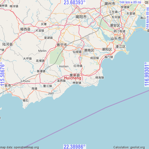
| Map corner | latitude | longitude |
|---|---|---|
| Upper-left | 23.68393°, | 115.58676° |
| Center: | 23.03845°, | 116.28988° |
| Lower-right: | 22.38986°, | 116.99301° |
| Map W x H: | 143.9×143.9 km | = 89.4×89.4mi |
| max Lat: | 53.31946° ⇑94.3% North |
| Huicheng: | 23.03845° |
| min Lat: | ⇓5.7% South 18.22056° |
| min Long | Huicheng | max Long |
| 75.07348° | 116.28988° | 134.28917° |
| W 61.7%⇐ | ⇒38.3% E |
Elevation
Elevation of Huicheng is 10 m = 33 ft, and this is 474.8 m = 1558 ft below average elevation for this country.
| Max E: |
5622 m = 18445 ft | 89.9% |
| Avg. | 484.8 m = 1591 ft | |
| Huicheng | 10 m = 33 ft | |
Min E: |
-3 m = -10 ft | 10.1% |
See also: Huicheng elevation on elevation.city.
Geographical zone
Huicheng is located in North Torrid zone (between Equator and Tropic of Cancer). Distance of this Northern Tropic circle is 44.3 km =27.5 mi to North.| Distance of | km | miles | from Huicheng |
|---|---|---|---|
| North Pole | 7445.4 | 4626.4 | to North |
| Arctic Circle | 4839.5 | 3007.1 | to North |
| Tropic Cancer | 44.3 | 27.5 | to North |
| Equator | 2561.6 | 1591.7 | to South |


Nearby cities:
15 places around Huicheng: (largest is in red/bold)
• Donglong
3.3 km =2.1 mi,  192°
192°
• Hongchang
9.3 km =5.8 mi,  13°
13°
• Huahu
6.4 km =4 mi,  96°
96°
• Jinghai
24.5 km =15.2 mi, 97°
• Leiling
9.4 km =5.8 mi,  56°
56°
• Liangying
21.2 km =13.2 mi,  18°
18°
• Longjiang
11.4 km =7.1 mi,  241°
241°
• Qianzhan
18.1 km =11.2 mi,  125°
125°
• Qishi
20.8 km =12.9 mi,  229°
229°
• Shenquan
7.9 km =4.9 mi,  160°
160°
• Xiajiashan
23.4 km =14.5 mi,  350°
350°
• Xiancheng
22.3 km =13.9 mi, 7°
• Xian’an
23.5 km =14.6 mi,  80°
80°
• Xixi
13.6 km =8.5 mi, 239°
• Zhoutian
17.4 km =10.8 mi, 100°
Sources, notices
• [Note1] Compared only with cities in China existing in our database
• [Src1] Map data: © OpenStreetMap contributors (CC-BY-SA)
• [Src2] Other city data from geonames.org with taken over terms of usage.
• [Src3] Geographical zone / Annual Mean Temperature by Robert A. Rohde @ Wikipedia
