Jiaxing geodata
Jiaxing (Zhejiang) is a seat of a second-order administrative division; located in China in Asia/Shanghai (GMT+8) time zone. With population of 466,101 people, there are 136 cities with bigger population in this country. Compared to other cities in China, 52.5% of cities are located further ↓South; 86.5% of cities are located further ←West and 92.7% of cities have higher elevation than Jiaxing. Note1


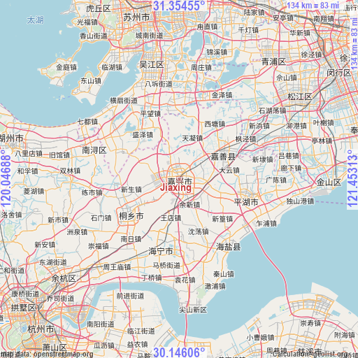
Jiaxing GPS coordinates[2]
30° 45' 7.92" North, 120° 45' 0" East
| Map corner | latitude | longitude |
|---|---|---|
| Upper-left | 31.35455°, | 120.04688° |
| Center: | 30.7522°, | 120.75° |
| Lower-right: | 30.14606°, | 121.45313° |
| Map W x H: | 134.4×134.4 km | = 83.5×83.5mi |
| max Lat: | 53.31946° ⇑47.5% North |
| Jiaxing: | 30.7522° |
| min Lat: | ⇓52.5% South 18.22056° |
| min Long | Jiaxing | max Long |
| 75.07348° | 120.75° | 134.28917° |
| W 86.5%⇐ | ⇒13.5% E |
Elevation
Elevation of Jiaxing is 8 m = 26 ft, and this is 476.8 m = 1564 ft below average elevation for this country.
| Max E: |
5622 m = 18445 ft | 92.7% |
| Avg. | 484.8 m = 1591 ft | |
| Jiaxing | 8 m = 26 ft | |
Min E: |
-3 m = -10 ft | 7.3% |
See also: Jiaxing elevation on elevation.city.
Geographical zone
Jiaxing is located in North temperate zone (between Tropic of Cancer and the Arctic Circle). Distance of this Northern Tropic circle is 813.4 km =505.4 mi to South.| Distance of | km | miles | from Jiaxing |
|---|---|---|---|
| North Pole | 6587.7 | 4093.4 | to North |
| Arctic Circle | 3981.8 | 2474.2 | to North |
| Tropic Cancer | 813.4 | 505.4 | to South |
| Equator | 3419.3 | 2124.7 | to South |


Nearby cities:
15 places around Jiaxing: (largest is in red/bold)
• Chengnan
2.6 km =1.6 mi,  229°
229°
• Daqiao
10.2 km =6.3 mi,  92°
92°
• Dongzha
3.6 km =2.2 mi,  73°
73°
• Fengqiao
14.2 km =8.8 mi,  135°
135°
• Hengjingqiao
11.7 km =7.3 mi, 228°
• Jiabei
4.8 km =3 mi,  309°
309°
• Jiefang
3.2 km =2 mi,  23°
23°
• Puyuan
14.1 km =8.8 mi,  235°
235°
• Qixing
9 km =5.6 mi,  40°
40°
• Tanghui
5.2 km =3.2 mi, 23°
• Wangdian
14.6 km =9.1 mi,  193°
193°
• Wangjiangjing
15.2 km =9.4 mi,  343°
343°
• Yangmiao
13.2 km =8.2 mi,  30°
30°
• Youchegang
8.5 km =5.3 mi,  358°
358°
• Yuxin
10 km =6.2 mi,  158°
158°
Sources, notices
• [Note1] Compared only with cities in China existing in our database
• [Src1] Map data: © OpenStreetMap contributors (CC-BY-SA)
• [Src2] Other city data from geonames.org with taken over terms of usage.
• [Src3] Geographical zone / Annual Mean Temperature by Robert A. Rohde @ Wikipedia
