Huoxian geodata
Huoxian (Beijing) is a seat of a fourth-order administrative division; located in China in Asia/Shanghai (GMT+8) time zone. In our database, there are 1268 cities with bigger population. Compared to other cities in China, 85.6% of cities are located further ↓South; 64.8% of cities are located further ←West and 83.4% of cities have higher elevation than Huoxian. Note1


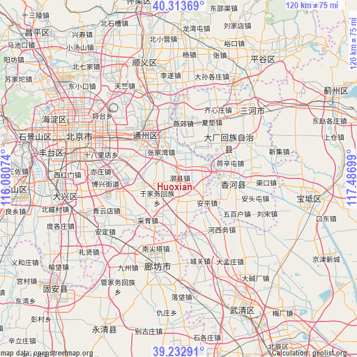
Huoxian GPS coordinates[2]
39° 46' 31.512" North, 116° 47' 1.896" East
| Map corner | latitude | longitude |
|---|---|---|
| Upper-left | 40.31369°, | 116.08074° |
| Center: | 39.77542°, | 116.78386° |
| Lower-right: | 39.23291°, | 117.48699° |
| Map W x H: | 120.2×120.2 km | = 74.7×74.7mi |
| max Lat: | 53.31946° ⇑14.4% North |
| Huoxian: | 39.77542° |
| min Lat: | ⇓85.6% South 18.22056° |
| min Long | Huoxian | max Long |
| 75.07348° | 116.78386° | 134.28917° |
| W 64.8%⇐ | ⇒35.2% E |
Elevation
Elevation of Huoxian is 19 m = 62 ft, and this is 465.8 m = 1528 ft below average elevation for this country.
| Max E: |
5622 m = 18445 ft | 83.4% |
| Avg. | 484.8 m = 1591 ft | |
| Huoxian | 19 m = 62 ft | |
Min E: |
-3 m = -10 ft | 16.6% |
See also: China elevation on elevation.city.
Geographical zone
Huoxian is located in North temperate zone (between Tropic of Cancer and the Arctic Circle). Distance of this Northern Tropic circle is 1816.7 km =1128.8 mi to South.| Distance of | km | miles | from Huoxian |
|---|---|---|---|
| North Pole | 5584.4 | 3470 | to North |
| Arctic Circle | 2978.6 | 1850.8 | to North |
| Tropic Cancer | 1816.7 | 1128.8 | to South |
| Equator | 4422.6 | 2748.1 | to South |


Nearby cities:
15 places around Huoxian: (largest is in red/bold)
• Beiyuan
18.4 km =11.4 mi,  320°
320°
• Caiyu
19.8 km =12.3 mi,  225°
225°
• Dongba
28.7 km =17.8 mi, 316°
• Gantang
9.2 km =5.7 mi,  13°
13°
• Jiugong
28.6 km =17.8 mi,  276°
276°
• Liyuan
15.3 km =9.5 mi,  314°
314°
• Qingyundian
26.1 km =16.2 mi,  245°
245°
• Songzhuang
19.7 km =12.2 mi,  345°
345°
• Taihu
13.8 km =8.6 mi,  296°
296°
• Tongzhou
17.7 km =11 mi, 323°
• Xiji
9.1 km =5.7 mi,  61°
61°
• Yongledian
7.4 km =4.6 mi,  184°
184°
• Yujiawu
9.2 km =5.7 mi, 228°
• Zhangjiawan
11.9 km =7.4 mi, 322°
• Zhangziying
19.3 km =12 mi,  237°
237°
Sources, notices
• [Note1] Compared only with cities in China existing in our database
• [Src1] Map data: © OpenStreetMap contributors (CC-BY-SA)
• [Src2] Other city data from geonames.org with taken over terms of usage.
• [Src3] Geographical zone / Annual Mean Temperature by Robert A. Rohde @ Wikipedia
