Liyuan geodata
Liyuan (Beijing) is a seat of a fourth-order administrative division; located in China in Asia/Shanghai (GMT+8) time zone. In our database, there are 1268 cities with bigger population. Compared to other cities in China, 86% of cities are located further ↓South; 64.1% of cities are located further ←West and 79.3% of cities have higher elevation than Liyuan. Note1


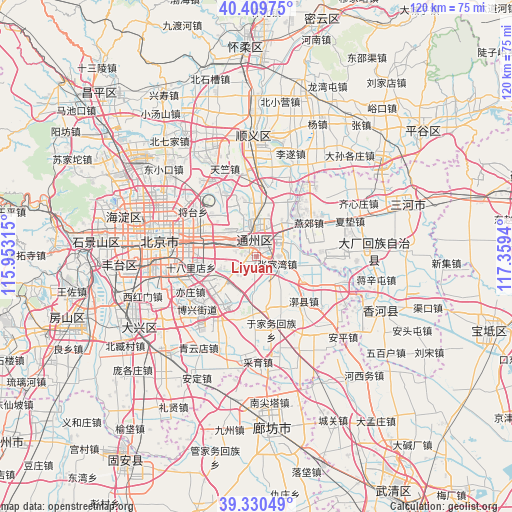
Liyuan GPS coordinates[2]
39° 52' 20.064" North, 116° 39' 22.572" East
| Map corner | latitude | longitude |
|---|---|---|
| Upper-left | 40.40975°, | 115.95315° |
| Center: | 39.87224°, | 116.65627° |
| Lower-right: | 39.33049°, | 117.3594° |
| Map W x H: | 120×120 km | = 74.6×74.6mi |
| max Lat: | 53.31946° ⇑14% North |
| Liyuan: | 39.87224° |
| min Lat: | ⇓86% South 18.22056° |
| min Long | Liyuan | max Long |
| 75.07348° | 116.65627° | 134.28917° |
| W 64.1%⇐ | ⇒35.9% E |
Elevation
Elevation of Liyuan is 28 m = 92 ft, and this is 456.8 m = 1499 ft below average elevation for this country.
| Max E: |
5622 m = 18445 ft | 79.3% |
| Avg. | 484.8 m = 1591 ft | |
| Liyuan | 28 m = 92 ft | |
Min E: |
-3 m = -10 ft | 20.7% |
See also: China elevation on elevation.city.
Geographical zone
Liyuan is located in North temperate zone (between Tropic of Cancer and the Arctic Circle). Distance of this Northern Tropic circle is 1827.5 km =1135.6 mi to South.| Distance of | km | miles | from Liyuan |
|---|---|---|---|
| North Pole | 5573.7 | 3463.3 | to North |
| Arctic Circle | 2967.8 | 1844.1 | to North |
| Tropic Cancer | 1827.5 | 1135.6 | to South |
| Equator | 4433.4 | 2754.8 | to South |


Nearby cities:
15 places around Liyuan: (largest is in red/bold)
• Beiyuan
3.6 km =2.2 mi,  346°
346°
• Chaowai
19.8 km =12.3 mi,  284°
284°
• Dongba
13.4 km =8.3 mi,  318°
318°
• Dongfeng
15.2 km =9.4 mi,  298°
298°
• Gantang
13.1 km =8.1 mi,  97°
97°
• Huoxian
15.3 km =9.5 mi,  134°
134°
• Jinzhan
16.5 km =10.3 mi,  333°
333°
• Jiugong
19.2 km =11.9 mi,  246°
246°
• Longtan
19.6 km =12.2 mi,  273°
273°
• Songzhuang
10.2 km =6.3 mi,  35°
35°
• Taihu
4.8 km =3 mi,  197°
197°
• Tongzhou
3.6 km =2.2 mi,  7°
7°
• Xiji
20 km =12.4 mi,  108°
108°
• Yujiawu
17.3 km =10.7 mi,  166°
166°
• Zhangjiawan
3.9 km =2.4 mi, 109°
Sources, notices
• [Note1] Compared only with cities in China existing in our database
• [Src1] Map data: © OpenStreetMap contributors (CC-BY-SA)
• [Src2] Other city data from geonames.org with taken over terms of usage.
• [Src3] Geographical zone / Annual Mean Temperature by Robert A. Rohde @ Wikipedia
