Dongba geodata
Dongba (Beijing) is a seat of a fourth-order administrative division; located in China in Asia/Shanghai (GMT+8) time zone. In our database, there are 1268 cities with bigger population. Compared to other cities in China, 86.3% of cities are located further ↓South; 63.4% of cities are located further ←West and 76.7% of cities have higher elevation than Dongba. Note1


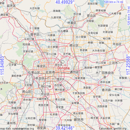
Dongba GPS coordinates[2]
39° 57' 45" North, 116° 33' 9.9" East
| Map corner | latitude | longitude |
|---|---|---|
| Upper-left | 40.49929°, | 115.84963° |
| Center: | 39.9625°, | 116.55275° |
| Lower-right: | 39.42146°, | 117.25588° |
| Map W x H: | 119.8×119.8 km | = 74.4×74.4mi |
| max Lat: | 53.31946° ⇑13.7% North |
| Dongba: | 39.9625° |
| min Lat: | ⇓86.3% South 18.22056° |
| min Long | Dongba | max Long |
| 75.07348° | 116.55275° | 134.28917° |
| W 63.4%⇐ | ⇒36.6% E |
Elevation
Elevation of Dongba is 33 m = 108 ft, and this is 451.8 m = 1482 ft below average elevation for this country.
| Max E: |
5622 m = 18445 ft | 76.7% |
| Avg. | 484.8 m = 1591 ft | |
| Dongba | 33 m = 108 ft | |
Min E: |
-3 m = -10 ft | 23.3% |
See also: China elevation on elevation.city.
Geographical zone
Dongba is located in North temperate zone (between Tropic of Cancer and the Arctic Circle). Distance of this Northern Tropic circle is 1837.5 km =1141.8 mi to South.| Distance of | km | miles | from Dongba |
|---|---|---|---|
| North Pole | 5563.6 | 3457.1 | to North |
| Arctic Circle | 2957.8 | 1837.9 | to North |
| Tropic Cancer | 1837.5 | 1141.8 | to South |
| Equator | 4443.4 | 2761 | to South |


Nearby cities:
15 places around Dongba: (largest is in red/bold)
• Beijing
14.6 km =9.1 mi,  245°
245°
• Beiyuan
10.3 km =6.4 mi,  129°
129°
• Chaowai
11.4 km =7.1 mi,  244°
244°
• Datun
11.8 km =7.3 mi,  283°
283°
• Dongfeng
5.4 km =3.4 mi, 237°
• Jingshan
13.3 km =8.3 mi, 251°
• Jinzhan
5 km =3.1 mi,  17°
17°
• Laiguangying
12.3 km =7.6 mi,  304°
304°
• Liqiao
13 km =8.1 mi,  31°
31°
• Liyuan
13.4 km =8.3 mi,  138°
138°
• Longtan
13.9 km =8.6 mi,  230°
230°
• Sunhe
9.4 km =5.8 mi,  344°
344°
• Tianzhu
10.7 km =6.6 mi,  9°
9°
• Tongzhou
11.4 km =7.1 mi,  124°
124°
• Wangjing
7.6 km =4.7 mi, 296°
Sources, notices
• [Note1] Compared only with cities in China existing in our database
• [Src1] Map data: © OpenStreetMap contributors (CC-BY-SA)
• [Src2] Other city data from geonames.org with taken over terms of usage.
• [Src3] Geographical zone / Annual Mean Temperature by Robert A. Rohde @ Wikipedia
