Huoshaoping geodata
Huoshaoping (Hubei) is a seat of a fourth-order administrative division; located in China in Asia/Shanghai (GMT+8) time zone. In our database, there are 1268 cities with bigger population. Compared to other cities in China, 50.4% of cities are located further ↓South; 68.2% of cities are located further →East and 93.5% of cities have lower elevation than Huoshaoping. Note1


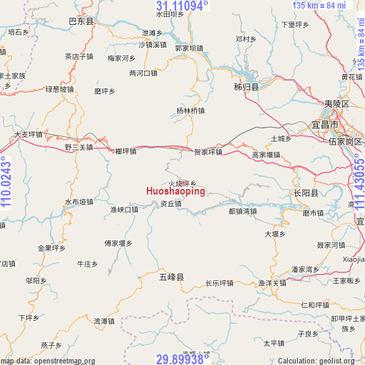
Huoshaoping GPS coordinates[2]
30° 30' 25.38" North, 110° 43' 38.712" East
| Map corner | latitude | longitude |
|---|---|---|
| Upper-left | 31.11094°, | 110.0243° |
| Center: | 30.50705°, | 110.72742° |
| Lower-right: | 29.89938°, | 111.43055° |
| Map W x H: | 134.7×134.7 km | = 83.7×83.7mi |
| max Lat: | 53.31946° ⇑49.6% North |
| Huoshaoping: | 30.50705° |
| min Lat: | ⇓50.4% South 18.22056° |
| min Long | Huoshaoping | max Long |
| 75.07348° | 110.72742° | 134.28917° |
| W 31.8%⇐ | ⇒68.2% E |
Elevation
Elevation of Huoshaoping is 1792 m = 5879 ft, and this is 1307.2 m = 4289 ft above average elevation for this country.
| Max E: |
5622 m = 18445 ft | 6.5% |
| Huoshaoping | 1792 m 5879 ft | |
| Avg. | 484.8 m = 1591 ft | |
Min E: |
-3 m = -10 ft | 93.5% |
See also: China elevation on elevation.city.
Geographical zone
Huoshaoping is located in North temperate zone (between Tropic of Cancer and the Arctic Circle). Distance of this Northern Tropic circle is 786.1 km =488.5 mi to South.| Distance of | km | miles | from Huoshaoping |
|---|---|---|---|
| North Pole | 6615 | 4110.4 | to North |
| Arctic Circle | 4009.1 | 2491.1 | to North |
| Tropic Cancer | 786.1 | 488.5 | to South |
| Equator | 3392.1 | 2107.8 | to South |


Nearby cities:
15 places around Huoshaoping: (largest is in red/bold)
• Changleping
39.3 km =24.4 mi,  159°
159°
• Dayan
39 km =24.2 mi,  118°
118°
• Duzhenwan
24.4 km =15.2 mi,  114°
114°
• Fujiayan
32.4 km =20.1 mi,  227°
227°
• Gaojiayan
33.4 km =20.8 mi,  70°
70°
• Hejiaping
14.6 km =9.1 mi,  40°
40°
• Langping
24.1 km =15 mi,  299°
299°
• Shuibuya
38.8 km =24.1 mi,  259°
259°
• Tucheng
39.9 km =24.8 mi, 65°
• Wufeng
34.3 km =21.3 mi,  185°
185°
• Yanglinqiao
27.1 km =16.8 mi,  6°
6°
• Yazikou
20.2 km =12.6 mi, 109°
• Yuxiakou
23.7 km =14.7 mi,  245°
245°
• Zhouping
37.7 km =23.4 mi, 7°
• Ziqiu
9.1 km =5.7 mi,  211°
211°
Sources, notices
• [Note1] Compared only with cities in China existing in our database
• [Src1] Map data: © OpenStreetMap contributors (CC-BY-SA)
• [Src2] Other city data from geonames.org with taken over terms of usage.
• [Src3] Geographical zone / Annual Mean Temperature by Robert A. Rohde @ Wikipedia
