Wufeng geodata
Wufeng (Hubei) is a seat of a third-order administrative division; located in China in Asia/Shanghai (GMT+8) time zone. In our database, there are 1268 cities with bigger population. Compared to other cities in China, 52% of cities are located further ↑North; 68.3% of cities are located further →East and 81.4% of cities have lower elevation than Wufeng. Note1


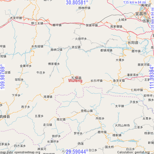
Wufeng GPS coordinates[2]
30° 12' 0" North, 110° 41' 26.916" East
| Map corner | latitude | longitude |
|---|---|---|
| Upper-left | 30.80581°, | 109.98769° |
| Center: | 30.2°, | 110.69081° |
| Lower-right: | 29.59044°, | 111.39394° |
| Map W x H: | 135.1×135.1 km | = 83.9×83.9mi |
| max Lat: | 53.31946° ⇑52% North |
| Wufeng: | 30.2° |
| min Lat: | ⇓48% South 18.22056° |
| min Long | Wufeng | max Long |
| 75.07348° | 110.69081° | 134.28917° |
| W 31.7%⇐ | ⇒68.3% E |
Elevation
Elevation of Wufeng is 760 m = 2493 ft, and this is 275.2 m = 903 ft above average elevation for this country.
| Max E: |
5622 m = 18445 ft | 18.6% |
| Wufeng | 760 m 2493 ft | |
| Avg. | 484.8 m = 1591 ft | |
Min E: |
-3 m = -10 ft | 81.4% |
See also: China elevation on elevation.city.
Geographical zone
Wufeng is located in North temperate zone (between Tropic of Cancer and the Arctic Circle). Distance of this Northern Tropic circle is 752 km =467.3 mi to South.| Distance of | km | miles | from Wufeng |
|---|---|---|---|
| North Pole | 6649.1 | 4131.6 | to North |
| Arctic Circle | 4043.2 | 2512.3 | to North |
| Tropic Cancer | 752 | 467.3 | to South |
| Equator | 3357.9 | 2086.5 | to South |


Nearby cities:
15 places around Wufeng: (largest is in red/bold)
• Caihua
23.3 km =14.5 mi,  274°
274°
• Changleping
17.3 km =10.7 mi,  99°
99°
• Dayan
40.8 km =25.4 mi,  67°
67°
• Duzhenwan
35 km =21.7 mi,  47°
47°
• Fujiayan
23.7 km =14.7 mi,  300°
300°
• Huoshaoping
34.3 km =21.3 mi,  5°
5°
• Nanzhen
39 km =24.2 mi,  200°
200°
• Nishi
30.6 km =19 mi,  164°
164°
• Niuzhuang
32 km =19.9 mi,  277°
277°
• Suojie
41.1 km =25.5 mi,  149°
149°
• Wantan
30.7 km =19.1 mi,  236°
236°
• Yazikou
35.5 km =22.1 mi,  39°
39°
• Yuxiakou
30.5 km =19 mi,  323°
323°
• Yuyangguan
36.5 km =22.7 mi,  94°
94°
• Ziqiu
26.4 km =16.4 mi,  357°
357°
Sources, notices
• [Note1] Compared only with cities in China existing in our database
• [Src1] Map data: © OpenStreetMap contributors (CC-BY-SA)
• [Src2] Other city data from geonames.org with taken over terms of usage.
• [Src3] Geographical zone / Annual Mean Temperature by Robert A. Rohde @ Wikipedia
