Huochang geodata
Huochang (Hunan) is a seat of a fourth-order administrative division; located in China in Asia/Shanghai (GMT+8) time zone. In our database, there are 1268 cities with bigger population. Compared to other cities in China, 66.1% of cities are located further ↑North; 68.9% of cities are located further →East and 62% of cities have lower elevation than Huochang. Note1


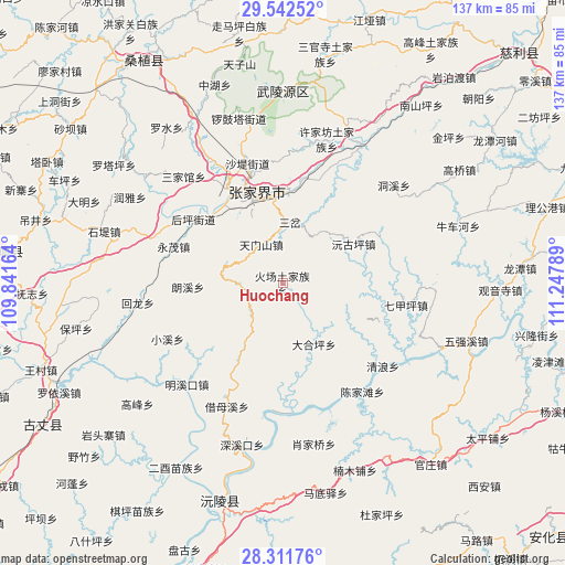
Huochang GPS coordinates[2]
28° 55' 44.292" North, 110° 32' 41.136" East
| Map corner | latitude | longitude |
|---|---|---|
| Upper-left | 29.54252°, | 109.84164° |
| Center: | 28.92897°, | 110.54476° |
| Lower-right: | 28.31176°, | 111.24789° |
| Map W x H: | 136.8×136.8 km | = 85×85mi |
| max Lat: | 53.31946° ⇑66.1% North |
| Huochang: | 28.92897° |
| min Lat: | ⇓33.9% South 18.22056° |
| min Long | Huochang | max Long |
| 75.07348° | 110.54476° | 134.28917° |
| W 31.1%⇐ | ⇒68.9% E |
Elevation
Elevation of Huochang is 283 m = 928 ft, and this is 201.8 m = 662 ft below average elevation for this country.
| Max E: |
5622 m = 18445 ft | 38% |
| Avg. | 484.8 m = 1591 ft | |
| Huochang | 283 m = 928 ft | |
Min E: |
-3 m = -10 ft | 62% |
See also: China elevation on elevation.city.
Geographical zone
Huochang is located in North temperate zone (between Tropic of Cancer and the Arctic Circle). Distance of this Northern Tropic circle is 610.7 km =379.5 mi to South.| Distance of | km | miles | from Huochang |
|---|---|---|---|
| North Pole | 6790.5 | 4219.4 | to North |
| Arctic Circle | 4184.6 | 2600.2 | to North |
| Tropic Cancer | 610.7 | 379.5 | to South |
| Equator | 3216.6 | 1998.7 | to South |


Nearby cities:
15 places around Huochang: (largest is in red/bold)
• Daping
10.6 km =6.6 mi,  331°
331°
• Fengxianggang
24.9 km =15.5 mi,  323°
323°
• Houping
26.6 km =16.5 mi,  305°
305°
• Jianxin
24 km =14.9 mi,  1°
1°
• Langxi
23 km =14.3 mi,  268°
268°
• Luoping
27.4 km =17 mi,  181°
181°
• Qijiaxi
12.1 km =7.5 mi,  123°
123°
• Sancha
14.9 km =9.3 mi,  7°
7°
• Shuangxiqiao
14.1 km =8.8 mi,  40°
40°
• Siduping
11.2 km =7 mi, 270°
• Xiejiaya
13.3 km =8.3 mi,  62°
62°
• Yinjiaxi
26.6 km =16.5 mi, 330°
• Yongmao
27.9 km =17.3 mi,  290°
290°
• Yuanguping
20 km =12.4 mi, 61°
• Zhangjiajie
23.2 km =14.4 mi,  343°
343°
Sources, notices
• [Note1] Compared only with cities in China existing in our database
• [Src1] Map data: © OpenStreetMap contributors (CC-BY-SA)
• [Src2] Other city data from geonames.org with taken over terms of usage.
• [Src3] Geographical zone / Annual Mean Temperature by Robert A. Rohde @ Wikipedia
