Daping geodata
Daping (Hunan) is a seat of a fourth-order administrative division; located in China in Asia/Shanghai (GMT+8) time zone. In our database, there are 1268 cities with bigger population. Compared to other cities in China, 65.3% of cities are located further ↑North; 69.1% of cities are located further →East and 75.2% of cities have lower elevation than Daping. Note1


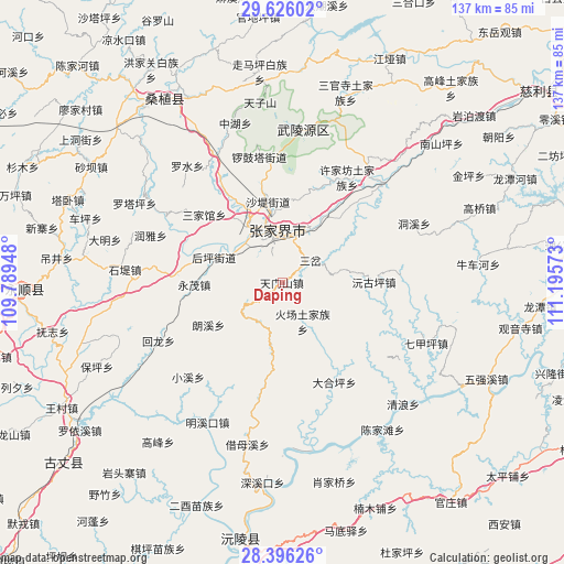
Daping GPS coordinates[2]
29° 0' 46.692" North, 110° 29' 33.36" East
| Map corner | latitude | longitude |
|---|---|---|
| Upper-left | 29.62602°, | 109.78948° |
| Center: | 29.01297°, | 110.4926° |
| Lower-right: | 28.39626°, | 111.19573° |
| Map W x H: | 136.7×136.7 km | = 84.9×84.9mi |
| max Lat: | 53.31946° ⇑65.3% North |
| Daping: | 29.01297° |
| min Lat: | ⇓34.7% South 18.22056° |
| min Long | Daping | max Long |
| 75.07348° | 110.4926° | 134.28917° |
| W 30.9%⇐ | ⇒69.1% E |
Elevation
Elevation of Daping is 526 m = 1726 ft, and this is 41.2 m = 135 ft above average elevation for this country.
| Max E: |
5622 m = 18445 ft | 24.8% |
| Daping | 526 m 1726 ft | |
| Avg. | 484.8 m = 1591 ft | |
Min E: |
-3 m = -10 ft | 75.2% |
See also: China elevation on elevation.city.
Geographical zone
Daping is located in North temperate zone (between Tropic of Cancer and the Arctic Circle). Distance of this Northern Tropic circle is 620 km =385.3 mi to South.| Distance of | km | miles | from Daping |
|---|---|---|---|
| North Pole | 6781.1 | 4213.6 | to North |
| Arctic Circle | 4175.2 | 2594.3 | to North |
| Tropic Cancer | 620 | 385.3 | to South |
| Equator | 3225.9 | 2004.5 | to South |


Nearby cities:
15 places around Daping: (largest is in red/bold)
• Fengxianggang
14.4 km =8.9 mi,  318°
318°
• Houping
17.7 km =11 mi,  289°
289°
• Huochang
10.6 km =6.6 mi,  151°
151°
• Jianxin
15.7 km =9.8 mi,  21°
21°
• Langxi
20.5 km =12.7 mi,  240°
240°
• Qijiaxi
22 km =13.7 mi,  136°
136°
• Sancha
8.9 km =5.5 mi,  51°
51°
• Shadi
19.9 km =12.4 mi,  351°
351°
• Shuangxiqiao
14.3 km =8.9 mi,  84°
84°
• Siduping
11 km =6.8 mi,  213°
213°
• Xiejiaya
17.2 km =10.7 mi,  101°
101°
• Xinqiao
19.7 km =12.2 mi,  3°
3°
• Yinjiaxi
16 km =9.9 mi,  329°
329°
• Yongmao
21.1 km =13.1 mi,  270°
270°
• Zhangjiajie
13 km =8.1 mi, 353°
Sources, notices
• [Note1] Compared only with cities in China existing in our database
• [Src1] Map data: © OpenStreetMap contributors (CC-BY-SA)
• [Src2] Other city data from geonames.org with taken over terms of usage.
• [Src3] Geographical zone / Annual Mean Temperature by Robert A. Rohde @ Wikipedia
