Zhangjiajie geodata
Zhangjiajie (Hunan) is a seat of a third-order administrative division; located in China in Asia/Shanghai (GMT+8) time zone. With population of 86,083 people, there are 495 cities with bigger population in this country. Compared to other cities in China, 64% of cities are located further ↑North; 69.1% of cities are located further →East and 51.1% of cities have lower elevation than Zhangjiajie. Note1


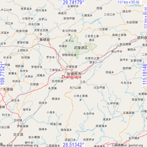
Zhangjiajie GPS coordinates[2]
29° 7' 45.984" North, 110° 28' 41.988" East
| Map corner | latitude | longitude |
|---|---|---|
| Upper-left | 29.74179°, | 109.77521° |
| Center: | 29.12944°, | 110.47833° |
| Lower-right: | 28.51342°, | 111.18146° |
| Map W x H: | 136.6×136.6 km | = 84.9×84.9mi |
| max Lat: | 53.31946° ⇑64% North |
| Zhangjiajie: | 29.12944° |
| min Lat: | ⇓36% South 18.22056° |
| min Long | Zhangjiajie | max Long |
| 75.07348° | 110.47833° | 134.28917° |
| W 30.9%⇐ | ⇒69.1% E |
Elevation
Elevation of Zhangjiajie is 174 m = 571 ft, and this is 310.8 m = 1020 ft below average elevation for this country.
| Max E: |
5622 m = 18445 ft | 48.9% |
| Avg. | 484.8 m = 1591 ft | |
| Zhangjiajie | 174 m = 571 ft | |
Min E: |
-3 m = -10 ft | 51.1% |
See also: Zhangjiajie elevation on elevation.city.
Geographical zone
Zhangjiajie is located in North temperate zone (between Tropic of Cancer and the Arctic Circle). Distance of this Northern Tropic circle is 633 km =393.3 mi to South.| Distance of | km | miles | from Zhangjiajie |
|---|---|---|---|
| North Pole | 6768.2 | 4205.6 | to North |
| Arctic Circle | 4162.3 | 2586.3 | to North |
| Tropic Cancer | 633 | 393.3 | to South |
| Equator | 3238.9 | 2012.6 | to South |


Nearby cities:
15 places around Zhangjiajie: (largest is in red/bold)
• Daping
13 km =8.1 mi,  173°
173°
• Fengxianggang
8.5 km =5.3 mi,  255°
255°
• Hezuoqiao
13.6 km =8.5 mi,  43°
43°
• Houping
16.8 km =10.4 mi,  245°
245°
• Jianxin
7.3 km =4.5 mi,  76°
76°
• Liulang
18.4 km =11.4 mi,  9°
9°
• Sancha
11.2 km =7 mi,  131°
131°
• Sanjiaguan
18.7 km =11.6 mi,  281°
281°
• Shadi
6.9 km =4.3 mi,  347°
347°
• Shuangxiqiao
19.4 km =12.1 mi, 126°
• Siduping
22.6 km =14 mi,  191°
191°
• Sigangtou
19.8 km =12.3 mi,  74°
74°
• Xinqiao
7.2 km =4.5 mi,  22°
22°
• Xujiafang
21.3 km =13.2 mi,  53°
53°
• Yinjiaxi
6.8 km =4.2 mi, 277°
Sources, notices
• [Note1] Compared only with cities in China existing in our database
• [Src1] Map data: © OpenStreetMap contributors (CC-BY-SA)
• [Src2] Other city data from geonames.org with taken over terms of usage.
• [Src3] Geographical zone / Annual Mean Temperature by Robert A. Rohde @ Wikipedia
