Xiejiaya geodata
Xiejiaya (Hunan) is a seat of a fourth-order administrative division; located in China in Asia/Shanghai (GMT+8) time zone. In our database, there are 1268 cities with bigger population. Compared to other cities in China, 65.6% of cities are located further ↑North; 68.5% of cities are located further →East and 65.6% of cities have lower elevation than Xiejiaya. Note1


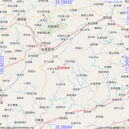
Xiejiaya GPS coordinates[2]
28° 58' 59.988" North, 110° 40' 0.012" East
| Map corner | latitude | longitude |
|---|---|---|
| Upper-left | 29.59656°, | 109.96355° |
| Center: | 28.98333°, | 110.66667° |
| Lower-right: | 28.36644°, | 111.3698° |
| Map W x H: | 136.8×136.8 km | = 85×85mi |
| max Lat: | 53.31946° ⇑65.6% North |
| Xiejiaya: | 28.98333° |
| min Lat: | ⇓34.4% South 18.22056° |
| min Long | Xiejiaya | max Long |
| 75.07348° | 110.66667° | 134.28917° |
| W 31.5%⇐ | ⇒68.5% E |
Elevation
Elevation of Xiejiaya is 336 m = 1102 ft, and this is 148.8 m = 488 ft below average elevation for this country.
| Max E: |
5622 m = 18445 ft | 34.4% |
| Avg. | 484.8 m = 1591 ft | |
| Xiejiaya | 336 m = 1102 ft | |
Min E: |
-3 m = -10 ft | 65.6% |
See also: China elevation on elevation.city.
Geographical zone
Xiejiaya is located in North temperate zone (between Tropic of Cancer and the Arctic Circle). Distance of this Northern Tropic circle is 616.7 km =383.2 mi to South.| Distance of | km | miles | from Xiejiaya |
|---|---|---|---|
| North Pole | 6784.4 | 4215.6 | to North |
| Arctic Circle | 4178.5 | 2596.4 | to North |
| Tropic Cancer | 616.7 | 383.2 | to South |
| Equator | 3222.6 | 2002.4 | to South |


Nearby cities:
15 places around Xiejiaya: (largest is in red/bold)
• Canmang
23.1 km =14.4 mi,  108°
108°
• Daping
17.2 km =10.7 mi,  281°
281°
• Dongxi
23.4 km =14.5 mi,  41°
41°
• Huochang
13.3 km =8.3 mi,  242°
242°
• Jianxin
21.2 km =13.2 mi,  327°
327°
• Nanmu
26.2 km =16.3 mi,  115°
115°
• Qijiaping
21.2 km =13.2 mi, 121°
• Qijiaxi
12.9 km =8 mi,  188°
188°
• Sancha
13.3 km =8.3 mi,  311°
311°
• Shuangxiqiao
5.4 km =3.4 mi, 330°
• Siduping
23.8 km =14.8 mi,  255°
255°
• Sigangtou
21.5 km =13.4 mi,  2°
2°
• Wangjiaping
16 km =9.9 mi,  64°
64°
• Yuanguping
6.7 km =4.2 mi, 57°
• Zhangjiajie
24.5 km =15.2 mi, 311°
Sources, notices
• [Note1] Compared only with cities in China existing in our database
• [Src1] Map data: © OpenStreetMap contributors (CC-BY-SA)
• [Src2] Other city data from geonames.org with taken over terms of usage.
• [Src3] Geographical zone / Annual Mean Temperature by Robert A. Rohde @ Wikipedia
