Hulu geodata
Hulu (Hunan) is a seat of a fourth-order administrative division; located in China in Asia/Shanghai (GMT+8) time zone. In our database, there are 1268 cities with bigger population. Compared to other cities in China, 69.4% of cities are located further ↑North; 72.5% of cities are located further →East and 66.1% of cities have lower elevation than Hulu. Note1


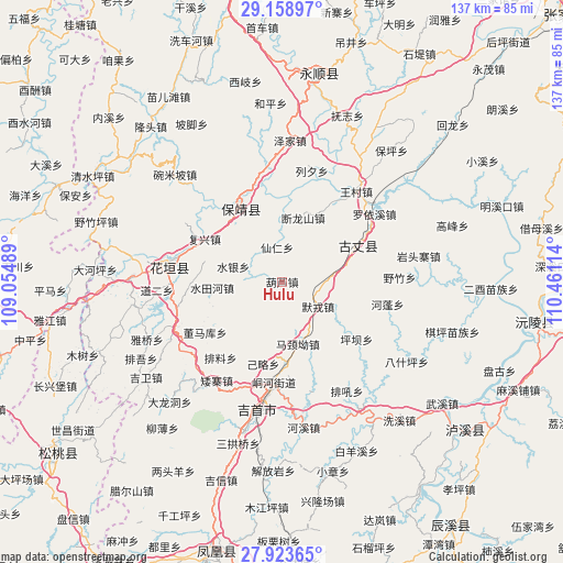
Hulu GPS coordinates[2]
28° 32' 35.232" North, 109° 45' 28.836" East
| Map corner | latitude | longitude |
|---|---|---|
| Upper-left | 29.15897°, | 109.05489° |
| Center: | 28.54312°, | 109.75801° |
| Lower-right: | 27.92365°, | 110.46114° |
| Map W x H: | 137.4×137.4 km | = 85.4×85.4mi |
| max Lat: | 53.31946° ⇑69.4% North |
| Hulu: | 28.54312° |
| min Lat: | ⇓30.6% South 18.22056° |
| min Long | Hulu | max Long |
| 75.07348° | 109.75801° | 134.28917° |
| W 27.5%⇐ | ⇒72.5% E |
Elevation
Elevation of Hulu is 346 m = 1135 ft, and this is 138.8 m = 455 ft below average elevation for this country.
| Max E: |
5622 m = 18445 ft | 33.9% |
| Avg. | 484.8 m = 1591 ft | |
| Hulu | 346 m = 1135 ft | |
Min E: |
-3 m = -10 ft | 66.1% |
See also: China elevation on elevation.city.
Geographical zone
Hulu is located in North temperate zone (between Tropic of Cancer and the Arctic Circle). Distance of this Northern Tropic circle is 567.8 km =352.8 mi to South.| Distance of | km | miles | from Hulu |
|---|---|---|---|
| North Pole | 6833.4 | 4246.1 | to North |
| Arctic Circle | 4227.5 | 2626.8 | to North |
| Tropic Cancer | 567.8 | 352.8 | to South |
| Equator | 3173.7 | 1972 | to South |


Nearby cities:
15 places around Hulu: (largest is in red/bold)
• Baiyan
16.2 km =10.1 mi,  145°
145°
• Duanlongshan
16.4 km =10.2 mi,  18°
18°
• Fuxing
21.6 km =13.4 mi,  298°
298°
• Guyang
18.8 km =11.7 mi,  65°
65°
• Jilue
20.6 km =12.8 mi,  193°
193°
• Majing’ao
15.7 km =9.8 mi,  165°
165°
• Meihua
20 km =12.4 mi,  330°
330°
• Morong
10.6 km =6.6 mi,  124°
124°
• Qianling
21.7 km =13.5 mi, 329°
• Shuangxi
14.4 km =8.9 mi,  56°
56°
• Shuitianhe
17.1 km =10.6 mi,  266°
266°
• Shuiyin
12.5 km =7.8 mi,  287°
287°
• Tuzha
7.7 km =4.8 mi, 304°
• Xianren
8.5 km =5.3 mi,  351°
351°
• Yangchao
14.7 km =9.1 mi,  336°
336°
Sources, notices
• [Note1] Compared only with cities in China existing in our database
• [Src1] Map data: © OpenStreetMap contributors (CC-BY-SA)
• [Src2] Other city data from geonames.org with taken over terms of usage.
• [Src3] Geographical zone / Annual Mean Temperature by Robert A. Rohde @ Wikipedia
