Hujiaba geodata
Hujiaba (Shaanxi) is a seat of a fourth-order administrative division; located in China in Asia/Shanghai (GMT+8) time zone. In our database, there are 1268 cities with bigger population. Compared to other cities in China, 65.9% of cities are located further ↓South; 85.2% of cities are located further →East and 79.1% of cities have lower elevation than Hujiaba. Note1


Hujiaba GPS coordinates[2]
32° 58' 39.324" North, 106° 28' 7.716" East
| Map corner | latitude | longitude |
|---|---|---|
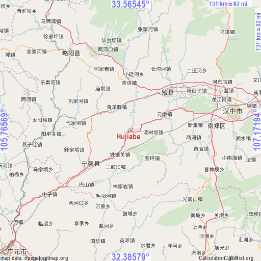
| Upper-left | 33.56545°, | 105.76569° |
| Center: | 32.97759°, | 106.46881° |
| Lower-right: | 32.38579°, | 107.17194° |
| Map W x H: | 131.2×131.2 km | = 81.5×81.5mi |
| max Lat: | 53.31946° ⇑34.1% North |
| Hujiaba: | 32.97759° |
| min Lat: | ⇓65.9% South 18.22056° |
| min Long | Hujiaba | max Long |
| 75.07348° | 106.46881° | 134.28917° |
| W 14.8%⇐ | ⇒85.2% E |
Elevation
Elevation of Hujiaba is 655 m = 2149 ft, and this is 170.2 m = 558 ft above average elevation for this country.
| Max E: |
5622 m = 18445 ft | 20.9% |
| Hujiaba | 655 m 2149 ft | |
| Avg. | 484.8 m = 1591 ft | |
Min E: |
-3 m = -10 ft | 79.1% |
See also: China elevation on elevation.city.
Geographical zone
Hujiaba is located in North temperate zone (between Tropic of Cancer and the Arctic Circle). Distance of this Northern Tropic circle is 1060.8 km =659.2 mi to South.| Distance of | km | miles | from Hujiaba |
|---|---|---|---|
| North Pole | 6340.3 | 3939.7 | to North |
| Arctic Circle | 3734.4 | 2320.4 | to North |
| Tropic Cancer | 1060.8 | 659.2 | to South |
| Equator | 3666.8 | 2278.4 | to South |


Nearby cities:
15 places around Hujiaba: (largest is in red/bold)
• Chadian
23.4 km =14.5 mi,  358°
358°
• Da’an
18.3 km =11.4 mi,  298°
298°
• Dingjunshan
25.3 km =15.7 mi,  44°
44°
• Fuchuan
20.8 km =12.9 mi,  82°
82°
• Hanyuan
25.9 km =16.1 mi,  231°
231°
• Kuanchuan
19.6 km =12.2 mi,  275°
275°
• Miaoba
25.3 km =15.7 mi,  326°
326°
• Nanping
8.4 km =5.2 mi, 299°
• Qingyangyi
14 km =8.7 mi, 328°
• Qishuba
11.8 km =7.3 mi,  100°
100°
• Tuguanpu
18.6 km =11.6 mi,  24°
24°
• Wuhou
23.5 km =14.6 mi, 35°
• Xiaohemiao
18.5 km =11.5 mi, 96°
• Xinpu
13.7 km =8.5 mi,  352°
352°
• Yuandun
16.8 km =10.4 mi,  70°
70°
Sources, notices
• [Note1] Compared only with cities in China existing in our database
• [Src1] Map data: © OpenStreetMap contributors (CC-BY-SA)
• [Src2] Other city data from geonames.org with taken over terms of usage.
• [Src3] Geographical zone / Annual Mean Temperature by Robert A. Rohde @ Wikipedia
