Hongchang geodata
Hongchang (Guangdong) is a seat of a fourth-order administrative division; located in China in Asia/Shanghai (GMT+8) time zone. In our database, there are 1268 cities with bigger population. Compared to other cities in China, 93.9% of cities are located further ↑North; 61.8% of cities are located further ←West and 58.9% of cities have lower elevation than Hongchang. Note1


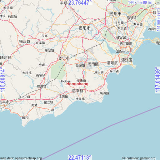
Hongchang GPS coordinates[2]
23° 7' 9.768" North, 116° 18' 40.536" East
| Map corner | latitude | longitude |
|---|---|---|
| Upper-left | 23.76447°, | 115.60814° |
| Center: | 23.11938°, | 116.31126° |
| Lower-right: | 22.47118°, | 117.01439° |
| Map W x H: | 143.8×143.8 km | = 89.4×89.4mi |
| max Lat: | 53.31946° ⇑93.9% North |
| Hongchang: | 23.11938° |
| min Lat: | ⇓6.1% South 18.22056° |
| min Long | Hongchang | max Long |
| 75.07348° | 116.31126° | 134.28917° |
| W 61.8%⇐ | ⇒38.2% E |
Elevation
Elevation of Hongchang is 246 m = 807 ft, and this is 238.8 m = 783 ft below average elevation for this country.
| Max E: |
5622 m = 18445 ft | 41.1% |
| Avg. | 484.8 m = 1591 ft | |
| Hongchang | 246 m = 807 ft | |
Min E: |
-3 m = -10 ft | 58.9% |
See also: China elevation on elevation.city.
Geographical zone
Hongchang is located in North Torrid zone (between Equator and Tropic of Cancer). Distance of this Northern Tropic circle is 35.3 km =21.9 mi to North.| Distance of | km | miles | from Hongchang |
|---|---|---|---|
| North Pole | 7436.4 | 4620.8 | to North |
| Arctic Circle | 4830.5 | 3001.5 | to North |
| Tropic Cancer | 35.3 | 21.9 | to North |
| Equator | 2570.6 | 1597.3 | to South |


Nearby cities:
15 places around Hongchang: (largest is in red/bold)
• Chendian
17.4 km =10.8 mi,  1°
1°
• Chengtian
18.1 km =11.2 mi,  65°
65°
• Donglong
12.6 km =7.8 mi,  193°
193°
• Huahu
10.6 km =6.6 mi,  156°
156°
• Huicheng
9.3 km =5.8 mi, 193°
• Junbu
16.2 km =10.1 mi,  340°
340°
• Leiling
6.8 km =4.2 mi,  123°
123°
• Liangying
12 km =7.5 mi,  22°
22°
• Longjiang
19 km =11.8 mi,  220°
220°
• Lugang
19.2 km =11.9 mi,  52°
52°
• Shenquan
16.5 km =10.3 mi,  178°
178°
• Simapu
16.7 km =10.4 mi, 18°
• Xiajiashan
15.4 km =9.6 mi, 336°
• Xiancheng
13.1 km =8.1 mi, 2°
• Xiashan
18.7 km =11.6 mi,  39°
39°
Sources, notices
• [Note1] Compared only with cities in China existing in our database
• [Src1] Map data: © OpenStreetMap contributors (CC-BY-SA)
• [Src2] Other city data from geonames.org with taken over terms of usage.
• [Src3] Geographical zone / Annual Mean Temperature by Robert A. Rohde @ Wikipedia
