Qianshui geodata
Qianshui (Guangdong) is a seat of a fourth-order administrative division; located in China in Asia/Urumqi (GMT+6) time zone. In our database, there are 1268 cities with bigger population. Compared to other cities in China, 98% of cities are located further ↑North; 68.1% of cities are located further →East and 84.9% of cities have higher elevation than Qianshui. Note1


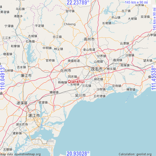
Qianshui GPS coordinates[2]
21° 35' 8.016" North, 110° 45' 8.1" East
| Map corner | latitude | longitude |
|---|---|---|
| Upper-left | 22.23789°, | 110.04913° |
| Center: | 21.58556°, | 110.75225° |
| Lower-right: | 20.93028°, | 111.45538° |
| Map W x H: | 145.4×145.4 km | = 90.3×90.3mi |
| max Lat: | 53.31946° ⇑98% North |
| Qianshui: | 21.58556° |
| min Lat: | ⇓2% South 18.22056° |
| min Long | Qianshui | max Long |
| 75.07348° | 110.75225° | 134.28917° |
| W 31.9%⇐ | ⇒68.1% E |
Elevation
Elevation of Qianshui is 16 m = 52 ft, and this is 468.8 m = 1538 ft below average elevation for this country.
| Max E: |
5622 m = 18445 ft | 84.9% |
| Avg. | 484.8 m = 1591 ft | |
| Qianshui | 16 m = 52 ft | |
Min E: |
-3 m = -10 ft | 15.1% |
See also: China elevation on elevation.city.
Geographical zone
Qianshui is located in North Torrid zone (between Equator and Tropic of Cancer). Distance of this Northern Tropic circle is 205.8 km =127.9 mi to North.| Distance of | km | miles | from Qianshui |
|---|---|---|---|
| North Pole | 7607 | 4726.8 | to North |
| Arctic Circle | 5001.1 | 3107.5 | to North |
| Tropic Cancer | 205.8 | 127.9 | to North |
| Equator | 2400.1 | 1491.4 | to South |


Nearby cities:
15 places around Qianshui: (largest is in red/bold)
• Aotou
11.5 km =7.1 mi,  108°
108°
• Bopu
15.8 km =9.8 mi,  164°
164°
• Changqi
6.5 km =4 mi,  207°
207°
• Dongshan
14.3 km =8.9 mi,  309°
309°
• Gongguan
14 km =8.7 mi,  38°
38°
• Hexi
15.4 km =9.6 mi,  298°
298°
• Hexi
16.6 km =10.3 mi, 312°
• Lanshi
10.9 km =6.8 mi,  135°
135°
• Tongqing
6.2 km =3.9 mi,  277°
277°
• Wuchuan
14.3 km =8.9 mi,  174°
174°
• Xiaguo
13.8 km =8.6 mi, 295°
• Xinpo
16.8 km =10.4 mi,  59°
59°
• Yangmei
15.5 km =9.6 mi,  252°
252°
• Zhangpu
16 km =9.9 mi,  201°
201°
• Zhencheng
10.3 km =6.4 mi,  74°
74°
Sources, notices
• [Note1] Compared only with cities in China existing in our database
• [Src1] Map data: © OpenStreetMap contributors (CC-BY-SA)
• [Src2] Other city data from geonames.org with taken over terms of usage.
• [Src3] Geographical zone / Annual Mean Temperature by Robert A. Rohde @ Wikipedia
