Shuanghejiedao geodata
Shuanghejiedao (Sichuan) is a seat of a third-order administrative division; located in China in Asia/Shanghai (GMT+8) time zone. In our database, there are 1268 cities with bigger population. Compared to other cities in China, 50.6% of cities are located further ↑North; 84.3% of cities are located further →East and 59.7% of cities have lower elevation than Shuanghejiedao. Note1


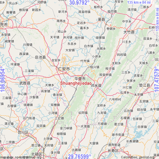
Shuanghejiedao GPS coordinates[2]
30° 22' 28.128" North, 106° 46' 21.576" East
| Map corner | latitude | longitude |
|---|---|---|
| Upper-left | 30.9792°, | 106.06954° |
| Center: | 30.37448°, | 106.77266° |
| Lower-right: | 29.76599°, | 107.47579° |
| Map W x H: | 134.9×134.9 km | = 83.8×83.8mi |
| max Lat: | 53.31946° ⇑50.6% North |
| Shuanghejiedao: | 30.37448° |
| min Lat: | ⇓49.4% South 18.22056° |
| min Long | Shuanghejiedao | max Long |
| 75.07348° | 106.77266° | 134.28917° |
| W 15.7%⇐ | ⇒84.3% E |
Elevation
Elevation of Shuanghejiedao is 256 m = 840 ft, and this is 228.8 m = 751 ft below average elevation for this country.
| Max E: |
5622 m = 18445 ft | 40.3% |
| Avg. | 484.8 m = 1591 ft | |
| Shuanghejiedao | 256 m = 840 ft | |
Min E: |
-3 m = -10 ft | 59.7% |
See also: China elevation on elevation.city.
Geographical zone
Shuanghejiedao is located in North temperate zone (between Tropic of Cancer and the Arctic Circle). Distance of this Northern Tropic circle is 771.4 km =479.3 mi to South.| Distance of | km | miles | from Shuanghejiedao |
|---|---|---|---|
| North Pole | 6629.7 | 4119.5 | to North |
| Arctic Circle | 4023.8 | 2500.3 | to North |
| Tropic Cancer | 771.4 | 479.3 | to South |
| Equator | 3377.3 | 2098.6 | to South |


Nearby cities:
15 places around Shuanghejiedao: (largest is in red/bold)
• Dawan
39.7 km =24.7 mi,  173°
173°
• Dingping
15.3 km =9.5 mi,  105°
105°
• Guang’an
17.1 km =10.6 mi,  310°
310°
• Jindaoxia
42.7 km =26.5 mi,  195°
195°
• Jiulong
36.8 km =22.9 mi,  299°
299°
• Laitan
35.3 km =21.9 mi,  231°
231°
• Longshi
35.1 km =21.8 mi,  239°
239°
• Sanhui
36.9 km =22.9 mi,  208°
208°
• Shayu
41.6 km =25.8 mi,  249°
249°
• Shitan
42.7 km =26.5 mi,  217°
217°
• Shuanghuai
29.7 km =18.5 mi, 224°
• Wanshun
41.8 km =26 mi,  152°
152°
• Xianglong
22.7 km =14.1 mi, 236°
• Xiaojia
30.6 km =19 mi, 251°
• Xiaomian
36.2 km =22.5 mi, 219°
Sources, notices
• [Note1] Compared only with cities in China existing in our database
• [Src1] Map data: © OpenStreetMap contributors (CC-BY-SA)
• [Src2] Other city data from geonames.org with taken over terms of usage.
• [Src3] Geographical zone / Annual Mean Temperature by Robert A. Rohde @ Wikipedia
